1960s Maps of Jefferson County, Indiana
Explore 6 historic maps of Jefferson County from the 1960s. These maps offer a rare glimpse into what life looked like during the 1960s — showing old roads, neighborhoods, homes, and landmarks that have changed or disappeared over time.
Whether you're researching your family's past, planning a metal detecting trip, or studying how Jefferson County's landscape evolved across the 1960s, these high-resolution maps are a powerful tool for exploring the history of this region.
- Focus on a specific era: All maps on this page are from the 1960s, giving you a focused view of this time period.
- See what’s changed: Compare century-old streets, trails, and buildings to today's modern landscape using overlays and satellite layers.
- Research with precision: Use these maps for genealogy, historical research, land use analysis, or educational projects.
- View, download, or print: Maps are fully viewable online in high resolution, and can be downloaded or printed for your own records.
Start exploring Jefferson County's history through authentic maps from the 1960s. This is your window into the past.
Jefferson County, IN maps
(6)- 1964 Map of Louisville
 1964 Louisville1964 Print · USGSThe Ohio River valley and Kentucky Bluegrass are captured in the mid-1960s, showing a region balanced between industrial growth and its agrarian roots. Genealogists and historians can trace the development of county seats like Shelbyville and Paris, or locate established institutions such as Georgetown College and Bernheim Forest.
 - 1964 Map of Clifty Falls, 1965 Print
 1964 Clifty Falls1965 Print · USGSMadison and its rugged creek valleys are captured in the mid-sixties, showcasing the area's transition from the sprawling military reservation to the Ohio River bluffs. Researchers can trace historic family burial sites like St Patricks Cem and landmarks such as Hanging Rock and Wirt Station.3 unique versions available
 - 1964 Map of Madison West, 1966 Print
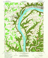 1964 Madison West1966 Print · USGSThe Indiana-Kentucky borderlands come into focus during the mid-sixties, dominated by the winding river and the bluff-top campuses of the Madison area. Researchers can trace the grounds of Hanover College, the Madison State Hospital, and numerous family burial sites like Moffett Cem and Zion Cem.5 unique versions available
 - 1967 Map of Carrollton, 1970 Print
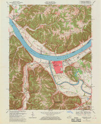 1967 Carrollton1970 Print · USGSThe confluence of the Kentucky and Ohio Rivers defines this late 1960s landscape, where the bustling streets of Carrollton meet the river economy. Genealogists and historians can trace local landmarks like St Johns Sch, the IOOF Cem, and the rural Old Bethel Cem across the Indiana border.4 unique versions available
 - 1968 Map of Deputy, 1970 Print
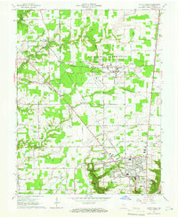
 1968 Deputy1970 Print · USGSThe rural landscape around Deputy and Paris Crossing is captured here in the late 1960s, showing the intersection of railroad life and the Muscatatuck River valley. Genealogists can trace family landmarks like Robertson Cem, Mt Zion Ch, and the Baltimore and Ohio rail line.3 unique versions available
 - 1968 Map of Blocher, 1971 Print
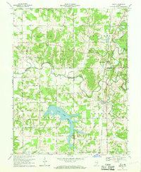
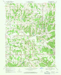 1968 Blocher1971 Print · USGSSoutheastern Indiana's rural crossroads and rail towns are captured here in the late sixties. Researchers can pinpoint long-standing community landmarks like Scaffold Lick Ch, the Baltimore and Ohio rail line, and Lexington Cem.4 unique versions available
End of results
Showing maps 1-6 of 6
Top cities of Jefferson County
- Madison historical maps
- Hanover historical maps
- Lancaster historical maps
- Saluda historical maps
- Smyrna historical maps
- Dupont historical maps
See more
Frequently asked questions
- What are the different types of historical maps available for Jefferson County?
- What is the oldest map of Jefferson County?
- Where can I purchase historical maps of Jefferson County for my home or office?
- Where can I download high-res historical maps of Jefferson County?
- Are there historical topographic maps available for Jefferson County?
- Is there historical aerial imagery available for Jefferson County?
- Where are historical maps of Jefferson County sourced from?