1900s (20th Century) Maps of Brooksburg, Indiana
Explore 7 historic maps of Brooksburg from the 1900s (20th Century). These maps offer a rare glimpse into what life looked like during the 1900s — showing old roads, neighborhoods, homes, and landmarks that have changed or disappeared over time.
Whether you're researching your family's past, planning a metal detecting trip, or studying how Brooksburg's landscape evolved across the 1900s, these high-resolution maps are a powerful tool for exploring the history of this region.
- Focus on a specific era: All maps on this page are from the 1900s, giving you a focused view of this time period.
- See what’s changed: Compare century-old streets, trails, and buildings to today's modern landscape using overlays and satellite layers.
- Research with precision: Use these maps for genealogy, historical research, land use analysis, or educational projects.
- View, download, or print: Maps are fully viewable online in high resolution, and can be downloaded or printed for your own records.
Start exploring Brooksburg's history through authentic maps from the 1900s. This is your window into the past.
Brooksburg, IN maps
(7)- 1943 Map of Brooksburg
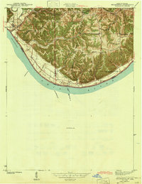 1943 Brooksburg1943 Print · USGSJefferson and Switzerland counties meet along the Ohio River in this early 1940s survey of the Indiana-Kentucky border. Trace the river-based economy and rural transit of the era through the Carrollton Ferry and family landmarks like Mc Kay Cem and McKay Sch.
 - 1953 Map of Carrollton, 1954 Print
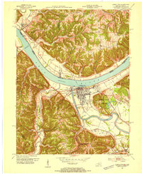 1953 Carrollton1954 Print · USGSThe confluence of the Ohio and Kentucky Rivers comes alive in the early 1950s, showing the riverside growth of Carrollton and Prestonville. Researchers can trace ancestral roots through sites like McKay Cemetery, Spring Branch Church, and River View School.2 unique versions available
 - 1956 Map of Louisville, 1971 Print
 1956 Louisville1971 Print · USGSThe Ohio River valley and the Kentucky Bluegrass are captured here during a period of rapid mid-century growth and industrial activity. Genealogists and historians can trace rail-centered towns and military land use at Fort Knox and the Jefferson Proving Ground.2 unique versions available
 - 1964 Map of Louisville
 1964 Louisville1964 Print · USGSThe Ohio River valley and Kentucky Bluegrass are captured in the mid-1960s, showing a region balanced between industrial growth and its agrarian roots. Genealogists and historians can trace the development of county seats like Shelbyville and Paris, or locate established institutions such as Georgetown College and Bernheim Forest.
 - 1967 Map of Carrollton, 1970 Print
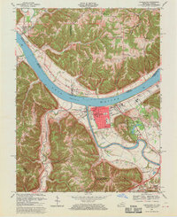 1967 Carrollton1970 Print · USGSThe confluence of the Kentucky and Ohio Rivers defines this late 1960s landscape, where the bustling streets of Carrollton meet the river economy. Genealogists and historians can trace local landmarks like St Johns Sch, the IOOF Cem, and the rural Old Bethel Cem across the Indiana border.4 unique versions available
 - 1986 Map of Madison
 1986 Madison1986 Print · USGSSouthern Indiana and Northern Kentucky are shown here in the mid-eighties, centered on the river corridor and the sprawling Jefferson Proving Ground. Genealogists and historians can trace rail lines like the Seaboard System and locate river towns from Madison to Bethlehem.
 - 1990 Map of Madison, 1991 Print
 1990 Madison1991 Print · USGSThe Ohio River valley and the southern Indiana plains are documented here in the final decade of the twentieth century. Genealogists and historians can trace family-named crossroads and established rail towns like Dudleytown, Austin, and Crothersville along the P C RR line.
End of results
Showing maps 1-7 of 7
Top cities near Brooksburg
- Madison historical maps
- Carrollton historical maps
- Hanover historical maps
- Vevay historical maps
- Pleasant historical maps
- Bedford historical maps
See more
Frequently asked questions
- What are the different types of historical maps available for Brooksburg?
- What is the oldest map of Brooksburg?
- Where can I purchase historical maps of Brooksburg for my home or office?
- Where can I download high-res historical maps of Brooksburg?
- Are there historical topographic maps available for Brooksburg?
- Is there historical aerial imagery available for Brooksburg?
- Where are historical maps of Brooksburg sourced from?