Loading...
Loading map...1943 Map of Brooksburg
USGS Topo · Published 1943About this map
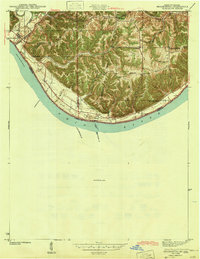
Brooksburg sits at the western edge of this survey, where Indian Kentucky Creek meets the wide sweep of the Ohio River. The landscape is defined by the sharp transition from the river bottomlands to the prominent elevations of Milton Ridge and Racket Ridge. A notable historic boundary, the Treaty Line, cuts north-south across the topography, marking a significant division in the early land layout of Jefferson and Switzerland counties.
Find a feature on this map
40 named features on this map. Tap any name to fly to it.
Don’t see what you’re looking for? This feature index may not catch every label — zoom into the map to look around manually.
Map Details
Date Portrayed1943
Date Published1943
PublisherU.S. Geological Survey
Map TypeTopographic
Scale1:24,000
Physical Dimensions20 x 25.8 inches
Editions of this 1943 Brooksburg Map
This is the sole edition of this map. No revisions or reprints were ever made.
Historical Maps of Carrollton Through Time
1 maps found
Featured Locations
Source Details
SourceU.S. Geological Survey
CopyrightPublic Domain