
1952 Map of Vevay South
USGS Topo · Published 1954About this map
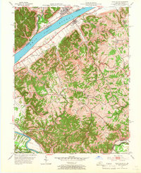
The Ohio River forms a wide, sweeping border between Indiana and Kentucky in this mid-century survey, anchoring the riverfront settlements of Vevay and Ghent. This area of Carroll and Switzerland counties relies on a complex network of waterways, with Mc Cools Creek and Whites Run carving through the uplands. Near the river, the County Infirmary and a Drive-in Theater represent two very different eras of community infrastructure. Further south, the landscape becomes increasingly rural and broken by drainage basins like Fourmile Creek and Buffalo Creek. The southern reaches are defined by the Kentucky River and the transit corridor of the Louisville and Nashville railroad, which serves the small community of Eagle Sta. This topography highlights how geography dictated early transportation, from river ferries to the rail lines winding through the Kentucky hills.
Find a feature on this map
32 named features on this map. Tap any name to fly to it.
Don’t see what you’re looking for? This feature index may not catch every label — zoom into the map to look around manually.
Map Details
Editions of this 1952 Vevay South Map
2 editions found
Other maps of this area

1943 · Florence
USGS Topo · 1:24,000

1943 · Vevay North
USGS Topo · 1:24,000

1943 · Brooksburg
USGS Topo · 1:24,000

1943 · Vevay South
USGS Topo · 1:24,000

1950 · New Liberty
USGS Topo · 1:24,000

1951 · Florence
USGS Topo · 1:24,000

1951 · Sanders
USGS Topo · 1:24,000

1952 · Worthville
USGS Topo · 1:24,000

1952 · Campbellsburg
USGS Topo · 1:24,000

1953 · Carrollton
USGS Topo · 1:24,000