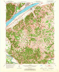
1952 Map of Vevay South
USGS Topo · Published 1966About this map
The Ohio River dominates the northern landscape of this mid-century survey, acting as the border between Vevay, Indiana, and the Kentucky shore. On the Kentucky side, the terrain transitions into a dense network of ridges and hollows defined by waterways like Whites Run and Fourmile Creek. The river economy is evident in the presence of Ghent and the various landings and ferries that once connected these river towns. Deep in the interior of Carroll County, rural life is marked by small gathering places such as Whites Run Ch and Marvin Chapel, alongside family-named landmarks like O'Neal Cem and Griffin Cem. To the south, the Louisville and Nashville railroad cuts through the valley near Eagle Sta, while the Kentucky River winds across the southwestern corner, illustrating the vital role of both rail and water transport in the region's development.
Find a feature on this map
35 named features on this map. Tap any name to fly to it.
Don’t see what you’re looking for? This feature index may not catch every label — zoom into the map to look around manually.
Map Details
Editions of this 1952 Vevay South Map
2 editions found
Other maps of this area

1943 · Florence
USGS Topo · 1:24,000

1943 · Vevay North
USGS Topo · 1:24,000

1943 · Brooksburg
USGS Topo · 1:24,000

1943 · Vevay South
USGS Topo · 1:24,000

1950 · New Liberty
USGS Topo · 1:24,000

1951 · Florence
USGS Topo · 1:24,000

1951 · Sanders
USGS Topo · 1:24,000

1952 · Vevay South
USGS Topo · 1:24,000

1952 · Worthville
USGS Topo · 1:24,000

1952 · Campbellsburg
USGS Topo · 1:24,000