
1943 Map of Florence
USGS Topo · Published 1943About this map
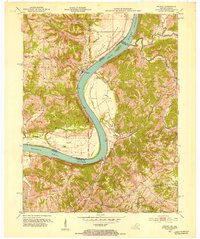
Florence sits at the base of the steep ridge-and-hollow terrain that defines the Indiana shoreline of the Ohio River. This 1940s landscape, surveyed by G. F. Westinghouse, is characterized by a series of prominent upland ridges including Cotton Ridge, York Ridge, and Bethel Ridge, which funnel drainage into waterways like Log Lick Creek and Turtle Creek. The riverfront activity centers on Dam 39 and the Warsaw Ferry crossing near the Kentucky border, reflecting the area's continued reliance on the river for transport and infrastructure. Scattered throughout the interior are the markers of a rural society, with several family-named landmarks and institutions like Bark Works Cem, Hastie Cem, and the Greenwood Sch serving the local farming population. The map provides a detailed view of the road network connecting the river settlements to the plateau above, where East Enterprise and Quercus Grove developed.
Find a feature on this map
32 named features on this map. Tap any name to fly to it.
Don’t see what you’re looking for? This feature index may not catch every label — zoom into the map to look around manually.
Map Details
Editions of this 1943 Florence Map
This is the sole edition of this map. No revisions or reprints were ever made.
Other maps of this area

1943 · Aberdeen
USGS Topo · 1:24,000

1943 · Vevay North
USGS Topo · 1:24,000

1943 · Rising Sun
USGS Topo · 1:24,000

1943 · Patriot
USGS Topo · 1:24,000

1943 · Vevay South
USGS Topo · 1:24,000

1950 · Glencoe
USGS Topo · 1:24,000

1951 · Florence
USGS Topo · 1:24,000

1951 · Rising Sun
USGS Topo · 1:24,000

1951 · Sanders
USGS Topo · 1:24,000
1951 · Patriot
USGS Topo · 1:24,000