
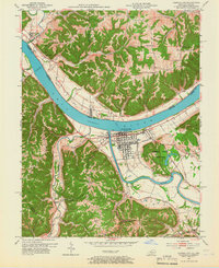
1953 Map of Carrollton
USGS Topo · Published 1954About this map
The Ohio River and Kentucky River converge at Carrollton, forming the geographical heart of this 1953 survey. The river valley is defined by steep ridges like Racket Ridge and Thorn Ridge, where small settlements and rural landmarks are scattered across the dissected plateau. In the town itself, the gridded street plan sits just north of the expansive General Butler State Park, while across the water, the Indiana shoreline features the small community of Brooksburg and the rural junction at Five Points. Genealogists and local historians will find significant detail in the numerous rural burial grounds and places of worship, such as the Old Bethel Cemetery and Mt Zion Church. The map also documents the industrial and educational landscape of the early 1950s, from the Quarry south of town to the River View School overlooking the Ohio.
Find a feature on this map
48 named features on this map. Tap any name to fly to it.
Don’t see what you’re looking for? This feature index may not catch every label — zoom into the map to look around manually.
Map Details
Editions of this 1953 Carrollton Map
2 editions found
Other maps of this area

1943 · Vevay North
USGS Topo · 1:24,000

1943 · Brooksburg
USGS Topo · 1:24,000

1943 · Vevay South
USGS Topo · 1:24,000

1952 · Vevay South
USGS Topo · 1:24,000

1952 · Worthville
USGS Topo · 1:24,000

1952 · Campbellsburg
USGS Topo · 1:24,000

1953 · Bedford
USGS Topo · 1:24,000

1953 · Madison East
USGS Topo · 1:24,000

1956 · Bennington
USGS Topo · 1:24,000

1956 · Canaan
USGS Topo · 1:24,000