1950s Maps of Knox County, Indiana
Explore 22 historic maps of Knox County from the 1950s. These maps offer a rare glimpse into what life looked like during the 1950s — showing old roads, neighborhoods, homes, and landmarks that have changed or disappeared over time.
Whether you're researching your family's past, planning a metal detecting trip, or studying how Knox County's landscape evolved across the 1950s, these high-resolution maps are a powerful tool for exploring the history of this region.
- Focus on a specific era: All maps on this page are from the 1950s, giving you a focused view of this time period.
- See what’s changed: Compare century-old streets, trails, and buildings to today's modern landscape using overlays and satellite layers.
- Research with precision: Use these maps for genealogy, historical research, land use analysis, or educational projects.
- View, download, or print: Maps are fully viewable online in high resolution, and can be downloaded or printed for your own records.
Start exploring Knox County's history through authentic maps from the 1950s. This is your window into the past.
Knox County, IN maps
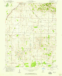
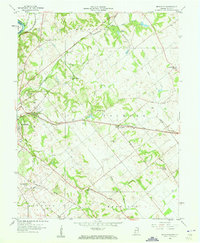
(22)- 1956 Map of Vincennes, 1967 Print
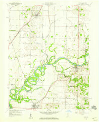
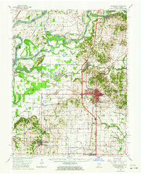
 1956 Vincennes1967 Print · USGSSouthern Indiana and the Illinois borderlands are captured here in the mid-fifties, showing the region's dense network of river towns and rail lines. Researchers can trace historic river crossings along the Wabash River or locate landmarks like Wyandotte Cave and Lincoln State Park.4 unique versions available
 - 1957 Map of Vincennes
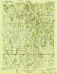
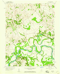
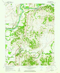
 1957 Vincennes1957 Print · USGSSouthwest Indiana and the Illinois borderlands come alive in the late 1950s, a period of heavy rail traffic and expanding state forests. Genealogists and historians can trace the riverfronts and rail lines of Vincennes, New Harmony, and the vast Crane Naval Ammunition Depot.
 - 1957 Map of Bucktown, 1958 Print
 1957 Bucktown1958 Print · USGSSoutheastern Sullivan County and northern Knox County appear here in the early 1940s as a landscape of rural homesteads and emerging coal works. Genealogists and historians can trace numerous family-named sites, including Benefiell Cem, Bethany Ch, and early Strip Mine operations.4 unique versions available
 - 1957 Map of Plainville, 1958 Print
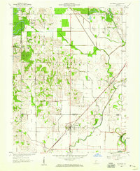
 1957 Plainville1958 Print · USGSDaviess and Knox counties are captured here in the late fifties, showcasing the intricate meanders of the White River. Genealogists and local historians can trace the foundations of Plainville and Westphalia, locating old Oil Wells, Salem Ch, and the Plainville Cem.3 unique versions available
 - 1957 Map of Carlisle, 1958 Print
 1957 Carlisle1958 Print · USGSMid-century Sullivan and Knox counties are captured here as agriculture and energy infrastructure shape the land. Genealogists can locate numerous burial sites like Odd Fellows Cem and Ledgerwood Cem near the Vincennes Tract Boundary.
 - 1957 Map of Washington, 1958 Print
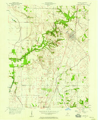
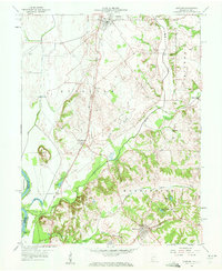
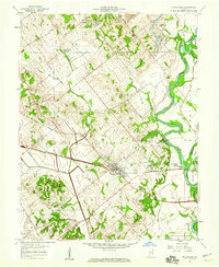
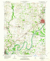
 1957 Washington1958 Print · USGSDaviess County's rail and river economy is on full display during the late 1950s, centered on the bustling hub of WASHINGTON. Researchers can trace old family sites and civic roots at St Johns Cem, Sugarland Ch, and the BALTIMORE AND OHIO RAILROAD corridor.4 unique versions available
 - 1957 Map of Epsom, 1958 Print
 1957 Epsom1958 Print · USGSDaviess County was undergoing an industrial transition in the late fifties as coal mining and oil production moved into its rural townships. Genealogists and historians can trace family locations through Epsom, Cornettsville, and remote sites like Ochiltree Cem or Bethel Ch.
 - 1958 Map of Vincennes
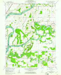
 1958 Vincennes1958 Print · USGSSouthern Indiana and the Illinois borderlands are captured during a mid-century period of heavy rail traffic and military activity. Researchers can trace the sprawling bounds of the Crane Naval Ammunition Depot or locate historic settlements like New Harmony and French Lick.2 unique versions available
 - 1958 Map of Monroe City, 1959 Print
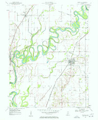
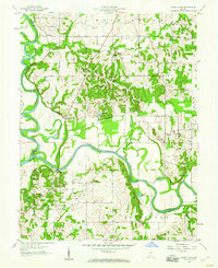
 1958 Monroe City1959 Print · USGSThe White River valley and the Beech Hills are captured in the late 1950s, showing a landscape shaped by coal, oil, and the railroad. Genealogists can trace family landmarks like Hamline Chapel, Reels Chapel, and the settlement of Monroe City.2 unique versions available
 - 1958 Map of Iona, 1959 Print
 1958 Iona1959 Print · USGSSouthwestern Indiana farmland meets the serpentine White River in the late fifties, where county lines converge at the water's edge. Genealogists can locate family sites at St Peters Cem or Johnson Cem and trace the rural settlements of Iona and Giro.3 unique versions available
 - 1958 Map of Sandborn, 1959 Print
 1958 Sandborn1959 Print · USGSThe Knox and Greene county borderlands come into focus in the late fifties, showing a rural landscape shaped by the White River and a network of drainage ditches. Researchers can trace historic family locations at Sandborn Cem and Marco, or locate the path of the Indian Treaty Boundary.2 unique versions available
 - 1958 Map of Oaktown, 1959 Print
 1958 Oaktown1959 Print · USGSKnox County, Indiana, at the end of the fifties reveals a landscape of established rail towns and rural cemeteries. Genealogists and local historians can locate Oaktown and Bruceville, while tracing family sites like Ocheltree Cem and the Maria Creek Ch.2 unique versions available
 - 1958 Map of Lyons, 1959 Print
 1958 Lyons1959 Print · USGSSouthern Indiana at the end of the 1950s was defined by the winding White River and its busy rail junctions. Genealogists and historians can trace family roots at Mt Zion Cem or explore the rail-dependent hamlets of Beehunter, Bushrod, and Ilene.
 - 1958 Map of Wheatland, 1959 Print
 1958 Wheatland1959 Print · USGSThe Knox County countryside was a mix of rail-side industry and quiet settlements in the late fifties. Genealogists and local historians can trace family-named sites like Asbury Cem or follow the Baltimore and Ohio line through Wheatland.3 unique versions available
 - 1958 Map of Sandy Hook, 1960 Print
 1958 Sandy Hook1960 Print · USGSDaviess County at the confluence of the White River forks shows its rural character during the late fifties. Genealogists can trace family connections through numerous landmarks like Union Cemetery, Letts School, and the settlement of Cumback.3 unique versions available
 - 1958 Map of Bicknell, 1960 Print
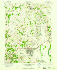 1958 Bicknell1960 Print · USGSKnox County was a hub of coal production and rail transport during the mid-century, with extensive excavations shaping the land. Researchers can trace the legacy of local families at Chambers Cem, explore the mining works near Johnstown, or locate the historic Bethel Ch.3 unique versions available
 - 1958 Map of Fritchton, 1960 Print
 1958 Fritchton1960 Print · USGSKnox County during the late fifties reveals a landscape defined by radiating rail lines and established rural institutions. Researchers can locate family landmarks such as St Vincents Orphanage, the County Farm, and Royal Oak Ch.2 unique versions available
 - 1959 Map of Mount Carmel, 1961 Print
 1959 Mount Carmel1961 Print · USGSMount Carmel sits at the confluence of the Wabash and White Rivers during the mid-century era, serving as a busy hub for both rail and river traffic. Genealogists and local historians can trace family roots through numerous sites like Nye Chapel, Schrodts Station, and the Sand Hill Cem.4 unique versions available
 - 1959 Map of East Mount Carmel, 1961 Print
 1959 East Mount Carmel1961 Print · USGSThe Illinois-Indiana borderlands meet at the confluence of the Wabash and White Rivers during the late fifties. Genealogists and historians can trace the Indian Treaty Boundary, locate Scott Chapel Cem, and see the Mount Carmel Ferry crossing.4 unique versions available
 - 1959 Map of Patoka, 1962 Print
 1959 Patoka1962 Print · USGSSouthwestern Indiana river country is captured here in the late fifties as the White River and Patoka River define the local landscape. Researchers can locate family roots at Shiloh Ch or trace old property lines near Milburn Cem and Decker Chapel Sch.4 unique versions available
 - 1959 Map of Mount Carmel, 1963 Print
 1959 Mount Carmel1963 Print · USGSMount Carmel and the Wabash River valley are shown here in the late fifties, during a period of active drainage and industrial growth. Genealogists can trace family landmarks like Keens Cem and Nisbet Chapel or explore the Old Indian Treaty Boundary and the paths of the Illinois Central railroad.2 unique versions available
 - 1959 Map of Princeton, 1964 Print
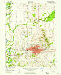
 1959 Princeton1964 Print · USGSIndiana's river-rich southwestern corner comes alive in the late fifties as a network of levees and railroads defines the landscape. Genealogists and historians can trace family roots through Lyles Sch, Decker Chapel, and the riverside settlements of Hazleton and Patoka.2 unique versions available
End of results
Showing maps 1-22 of 22
Top cities of Knox County
- Vincennes historical maps
- Bicknell historical maps
- Busseron historical maps
- Oaktown historical maps
- Monroe City historical maps
- Wheatland historical maps
See more
Frequently asked questions
- What are the different types of historical maps available for Knox County?
- What is the oldest map of Knox County?
- Where can I purchase historical maps of Knox County for my home or office?
- Where can I download high-res historical maps of Knox County?
- Are there historical topographic maps available for Knox County?
- Is there historical aerial imagery available for Knox County?
- Where are historical maps of Knox County sourced from?