Old Maps of Knox County, Indiana for Genealogy
Trace your family roots with 180 historic maps of Knox County. These high-res maps reveal old neighborhoods, homesites, landmarks, and streets — helping you uncover where your ancestors lived and how the area evolved over time.
- Explore historic neighborhoods: Identify where your relatives may have lived in the 1800s or 1900s.
- Compare maps over time: Trace the changes in streets, buildings, and landmarks for multi-generational research.
- Perfect for genealogy & ancestry research: Used by family historians and researchers to map out lineage and migration.
These maps are an incredible resource for exploring your personal connection to Knox County's past.
Knox County, IN maps
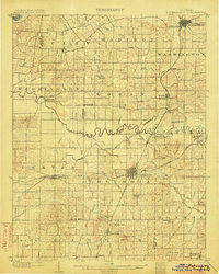
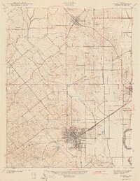
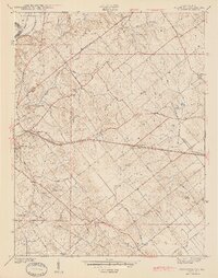
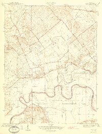
(180)- 1901 Map of Princeton, 1954 Print
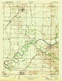
 1901 Princeton1954 Print · USGSGIBSON COUNTY at the turn of the century shows a landscape transitioning from river-and-canal transit to a bustling railroad hub. Trace early settlements and infrastructure like the Mt Carmel Ferry, the Wabash and Erie Canal (Abandoned), and the historic community of Lyles.
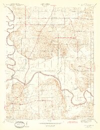
 - 1902 Map of Ditney
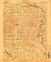
 1902 Ditney1902 Print · USGSSouthern Indiana at the start of the century was a landscape of expanding railroads and rural hamlets. Family historians can trace ancestral roots through dozens of small settlements like Coats Springs, Dongola, and Boonville along the Southern RR.3 unique versions available
 - 1903 Map of Petersburg
 1903 Petersburg1903 Print · USGSSouthwestern Indiana at the turn of the century reveals a landscape shaped by river commerce and the early coal industry. Genealogists can trace family roots in Petersburg or Oakland City, and locate the Erie Canal and Massey Mine.2 unique versions available
 - 1903 Map of Princeton
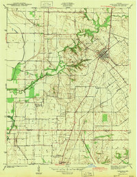
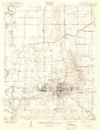
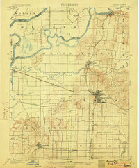 1903 Princeton1903 Print · USGSIndiana's southwestern river country is shown at the height of its railroad era, centered on the junction at Princeton. Genealogists and historians can trace old property lines near the County Farm or locate vanished sites along the Wabash and Erie Canal and the settlement of Lyles.6 unique versions available
 - 1903 Map of Patoka
 1903 Patoka1903 Print · USGSThe lower Wabash Valley at the start of the twentieth century was a vital crossroads of river trade and rail expansion. Genealogists can trace family roots through settlements like New Harmony and Parker's Settlement or locate the County Farm and Grand Rapids.2 unique versions available
 - 1904 Map of Mount Carmel
 1904 Mount Carmel1904 Print · USGSMount Carmel and the Wabash River valley are captured here at the height of the steam era. Genealogists and historians can trace defunct rail stops and riverside settlements like Schrodts Sta., Jimtown, and Rochester.3 unique versions available
 - 1915 Map of Vincennes
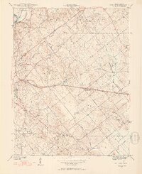
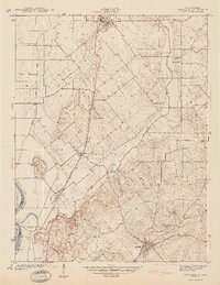
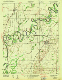
 1915 Vincennes1915 Print · USGSThe Wabash River valley comes to life in this early twentieth-century survey of the Illinois-Indiana border. Genealogists can trace family roots through numerous rural landmarks like St Francisville, the Sand Barrens School, and Adams Corners.5 unique versions available
 - 1917 Map of Birds
 1917 Birds1917 Print · USGSCrawford and Lawrence counties thrive along the Wabash River at the height of the rail era. Genealogists can trace family roots through dozens of local schools like Hazel Dell School and river landings such as Shaws Landing.2 unique versions available
 - 1942 Map of Fritchton
 1942 Fritchton1942 Print · USGSKnox County farmland and the eastern edge of Vincennes are captured in the early 1940s as a hub of rail transit and community institutions. Researchers can locate historic local landmarks like the St Vincent Orphanage, Fritchton Cem, and the Julian Mine.2 unique versions available
 - 1942 Map of Birds, 1958 Print
 1942 Birds1958 Print · USGSThe Wabash River valley comes to life in this mid-century survey of the Illinois-Indiana borderlands. Genealogists can locate family lands near Oil Grove or trace ancestors through rural landmarks like Buncombe School and Brightlight Ferry.
 - 1943 Map of Lyons
 1943 Lyons1943 Print · USGSThe Greene and Daviess County borderlands in the 1940s are defined by the winding WHITE RIVER and a busy junction of coal-era railroads. Trace family roots at FRYE CEM or Old Slinkard Cem, and locate long-standing community centers like Mud Pike Ch and Elnora.2 unique versions available
 - 1943 Map of Carlisle
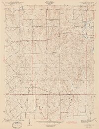
 1943 Carlisle1943 Print · USGSSouthern Sullivan County was a landscape of rail-linked towns and quiet country cemeteries in the years following the Great Depression. Genealogists and local historians can trace family roots through sites like Odd Fellows Cem or locate the old Shaker Prairie Ch along the Vincennes Tract.2 unique versions available
 - 1943 Map of Oaktown
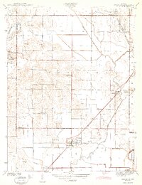
 1943 Oaktown1943 Print · USGSKnox County and the Illinois borderlands come alive in the early 1940s as steam-era railroads connect the farming communities of Oaktown and Bruceville. Local historians can trace family roots through numerous sites like Ocheltree Cem, Price Cem, and the Maria Creek Ch.2 unique versions available
 - 1943 Map of Sandborn
 1943 Sandborn1943 Print · USGSIn the early 1940s, this portion of Knox and Greene Counties was a busy corridor for coal mining and rail transport. Researchers can trace family history through local landmarks like Marco Cem, Pleasant Grove Ch, and the many Strip Mine works near Sponsler.2 unique versions available
 - 1943 Map of Bicknell
 1943 Bicknell1943 Print · USGSIn the early 1940s, this portion of Knox County was a hub of coal production and rail activity centered on the growing city of Bicknell. Genealogists and historians can locate numerous family burial sites like Walker Cem and trace the local mining economy through labels like Sunshine Mine and Panhandle Mine.2 unique versions available
 - 1943 Map of Plainville
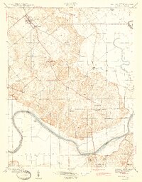
 1943 Plainville1943 Print · USGSDaviess and Knox Counties appear here in the early 1940s, where the winding loops of the White River dominate the agricultural landscape. Genealogists and local historians can trace family locations near Plainville, Westphalia, or the historic Vincennes Tract boundary.2 unique versions available
 - 1943 Map of Epsom
 1943 Epsom1943 Print · USGSDaviess County during the early 1940s is captured here through its intricate ditch systems and crossing rail lines. Genealogists can locate family landmarks like Tolberts Chapel Cem and Cornettsville or trace the path of the New York Central.2 unique versions available
 - 1944 Map of Bucktown
 1944 Bucktown1944 Print · USGSThe rural borders of Sullivan and Knox counties appear here during the early 1940s as traditional farming life met industrial coal extraction. Genealogists can locate family burial grounds like Land Cem and McDade Cem or rural centers such as Bucktown and Pleasantville.2 unique versions available
 - 1944 Map of Fritchton
 1944 Fritchton1944 Print · USGSKnox County during the mid-1940s is captured here as a crossroads of major railroads and farming townships just east of the Wabash. Local historians can trace the foundations of the community at the St Vincent Orphanage or follow the legacy of the Julian Mine and Royal Oak Ch.2 unique versions available
 - 1944 Map of Washington
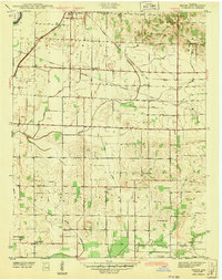
 1944 Washington1944 Print · USGSMid-century Washington and its neighboring Daviess County settlements are shown at their industrial peak as a central railroad crossroads. Genealogists and researchers can trace local families through many rural landmarks, including Hyatt Capehart P.O., St Johns Cem, and the Sugarland Sch.2 unique versions available
 - 1944 Map of Monroe City
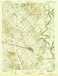
 1944 Monroe City1944 Print · USGSMonroe City and the surrounding Knox County bottomlands are captured here in the 1940s, just as the rural landscape was maturing. Researchers can trace family origins through numerous landmarks like Freeland Cemetery, Hamline Chapel, and Slickum School.2 unique versions available
 - 1944 Map of Wheatland
 1944 Wheatland1944 Print · USGSMid-century Knox County is defined by coal mining and rail transport at the height of the steam era. Genealogists and industrial historians can trace the Baltimore and Ohio Railroad through Wheatland and locate family-named sites like the Peacock Mine and Asbury Chapel.2 unique versions available
 - 1944 Map of Iona
 1944 Iona1944 Print · USGSKnox and Gibson counties meet along the high-banked curves of the White River in the early 1940s. Researchers can trace rural lineages through numerous local sites including Slow Cem, West Salem Cem, and the settlement at Iona.2 unique versions available
 - 1944 Map of Vincennes, 1958 Print
 1944 Vincennes1958 Print · USGSThe Wabash River valley during the mid-1940s reveals a landscape of river-town commerce and rural school districts. Genealogists can trace family roots through numerous sites like St Thomas church, the Bunker Hill School, and the small settlement at Billett.
 - 1945 Map of Sandy Hook
 1945 Sandy Hook1945 Print · USGSDaviess County was a landscape of small schoolhouses and river junctions during the 1940s. Genealogists and local historians can trace family locations near Union Cemetery or locate old community centers like Sandy Hook and Needmore Sch.2 unique versions available
Showing maps 1-25 of 180
Top cities of Knox County
- Vincennes historical maps
- Bicknell historical maps
- Busseron historical maps
- Oaktown historical maps
- Monroe City historical maps
- Wheatland historical maps
See more
Frequently asked questions
- What are the different types of historical maps available for Knox County?
- What is the oldest map of Knox County?
- Where can I purchase historical maps of Knox County for my home or office?
- Where can I download high-res historical maps of Knox County?
- Are there historical topographic maps available for Knox County?
- Is there historical aerial imagery available for Knox County?
- Where are historical maps of Knox County sourced from?