1990s Maps of Martin County, Indiana
Explore 7 historic maps of Martin County from the 1990s. These maps offer a rare glimpse into what life looked like during the 1990s — showing old roads, neighborhoods, homes, and landmarks that have changed or disappeared over time.
Whether you're researching your family's past, planning a metal detecting trip, or studying how Martin County's landscape evolved across the 1990s, these high-resolution maps are a powerful tool for exploring the history of this region.
- Focus on a specific era: All maps on this page are from the 1990s, giving you a focused view of this time period.
- See what’s changed: Compare century-old streets, trails, and buildings to today's modern landscape using overlays and satellite layers.
- Research with precision: Use these maps for genealogy, historical research, land use analysis, or educational projects.
- View, download, or print: Maps are fully viewable online in high resolution, and can be downloaded or printed for your own records.
Start exploring Martin County's history through authentic maps from the 1990s. This is your window into the past.
Martin County, IN maps
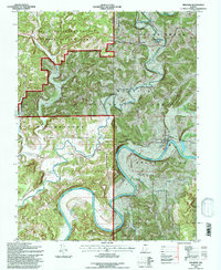
(7)- 1990 Map of Bedford, 1991 Print
 1990 Bedford1991 Print · USGSSouthern Indiana in the early nineties reveals a complex landscape of military reservations, resort towns, and heavy industry. Genealogists and historians can trace family sites like Old Union Cem and Trinity Springs or locate the limestone quarries surrounding Oolitic.
 - 1993 Map of Williams, 1996 Print
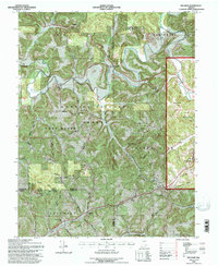
 1993 Williams1996 Print · USGSLawrence and Martin Counties come into focus in the 1990s as the river and railroad wind through deep forests and military holdings. Genealogists can locate family landmarks like Silverville Cem, Mt Pleasant Cem, and the community of Williams along the East Fork White River.
 - 1993 Map of Hillham, 1996 Print
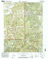
 1993 Hillham1996 Print · USGSSouthern Indiana's karst landscape is documented here in the early nineties, showing the interface between the Hoosier National Forest and historic resort towns. Genealogists can locate family sites like Natchez Cem, Emmons Ridge Cem, and the Burton Tunnel railroad passage.
 - 1993 Map of Shoals, 1998 Print
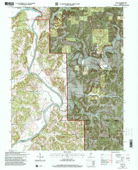
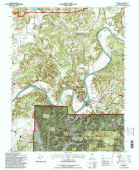 1993 Shoals1998 Print · USGSMartin County in the early 1990s is characterized by the winding path of the East Fork White River through dense forest and small river towns. Genealogists and local historians can trace family locations near Shoals, the historic McBrides Ferry crossing, and old landmarks like Poplar Grove Ch.
 - 1993 Map of Huron, 1998 Print
 1993 Huron1998 Print · USGSSouthern Indiana forest lands and river bends are captured here in the 1990s as the rail and road networks navigated the deep hollows of Martin and Lawrence Counties. You can trace the B & O RR through Huron or locate rural landmarks like Weisbach Ch and Willow Valley.4 unique versions available
 - 1993 Map of Rusk, 2000 Print
 1993 Rusk2000 Print · USGSThe East Fork White River winds through the Martin and Dubois County line in the early nineties, revealing a landscape of forested hollows and river bends. Genealogists and historians can locate rural landmarks such as South Martin Ch, Green Cem, and the tiny settlement of Yenne.
 - 1994 Map of Jasper
 1994 Jasper1994 Print · USGSSouthern Indiana and the Kentucky borderlands are captured here in the mid-nineties, showing a landscape defined by the Ohio River and dense state forests. Genealogists can locate family landmarks like Saint Meinrad Archabbey, Saint Anthony, and the historic Lincoln Boyhood National Memorial.
End of results
Showing maps 1-7 of 7
Top cities of Martin County
Frequently asked questions
- What are the different types of historical maps available for Martin County?
- What is the oldest map of Martin County?
- Where can I purchase historical maps of Martin County for my home or office?
- Where can I download high-res historical maps of Martin County?
- Are there historical topographic maps available for Martin County?
- Is there historical aerial imagery available for Martin County?
- Where are historical maps of Martin County sourced from?