1960s Maps of Bloomington, Indiana
Explore 4 historic maps of Bloomington from the 1960s. These maps offer a rare glimpse into what life looked like during the 1960s — showing old roads, neighborhoods, homes, and landmarks that have changed or disappeared over time.
Whether you're researching your family's past, planning a metal detecting trip, or studying how Bloomington's landscape evolved across the 1960s, these high-resolution maps are a powerful tool for exploring the history of this region.
- Focus on a specific era: All maps on this page are from the 1960s, giving you a focused view of this time period.
- See what’s changed: Compare century-old streets, trails, and buildings to today's modern landscape using overlays and satellite layers.
- Research with precision: Use these maps for genealogy, historical research, land use analysis, or educational projects.
- View, download, or print: Maps are fully viewable online in high resolution, and can be downloaded or printed for your own records.
Start exploring Bloomington's history through authentic maps from the 1960s. This is your window into the past.
Bloomington, IN maps
(4)- 1962 Map of Indianapolis
 1962 Indianapolis1962 Print · USGSCentral Indiana and the Illinois borderlands are captured here in the early sixties, showing the region's dense rail networks and growing urban centers. Genealogists and historians can locate family-named landmarks and institutions like Crown Hill Cem, Indiana University, and the Indianapolis Motor Speedway.
 - 1965 Map of Clear Creek, 1968 Print
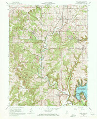 1965 Clear Creek1968 Print · USGSMonroe County in the mid-1960s is defined by the intersection of the expanding Monroe Reservoir and the established limestone industry. Genealogists and historians can trace local landmarks like Walkers Chapel, Clover Hill Cem, and the rail lines of the Monon Railroad.6 unique versions available
 - 1966 Map of Bloomington, 1967 Print
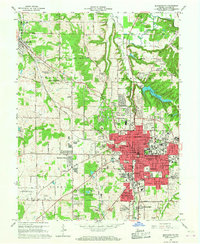 1966 Bloomington1967 Print · USGSMid-century Bloomington is captured in a period of significant growth, showing the city's expansion alongside its deep-rooted limestone industry. Researchers can trace the MONON rail line, locate dozens of neighborhood schools like Hensonburg Sch, and find family sites near Rose Hill Cemetery.4 unique versions available
 - 1966 Map of Unionville, 1968 Print
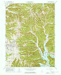 1966 Unionville1968 Print · USGSMonroe County enters a period of suburban growth and reforestation in the mid-sixties as the university town of Bloomington expands eastward. Researchers can trace rural cemeteries and community centers like Little Union Cem, Unionville, and the College Mall Shopping Center.5 unique versions available
End of results
Showing maps 1-4 of 4
Top cities near Bloomington
- Martinsville historical maps
- Ellettsville historical maps
- Clear Creek historical maps
- Spencer historical maps
- Guthrie historical maps
- Gosport historical maps
See more
Top neighborhoods of Bloomington
- Broadview historical maps
- Sunny Slopes historical maps
- Arlington historical maps
- Park Ridge historical maps
- Hyde Park Village historical maps
- Sycamore Knolls historical maps
See more
Frequently asked questions
- What are the different types of historical maps available for Bloomington?
- What is the oldest map of Bloomington?
- Where can I purchase historical maps of Bloomington for my home or office?
- Where can I download high-res historical maps of Bloomington?
- Are there historical topographic maps available for Bloomington?
- Is there historical aerial imagery available for Bloomington?
- Where are historical maps of Bloomington sourced from?