1990s Maps of Ellettsville, Indiana
Explore 3 historic maps of Ellettsville from the 1990s. These maps offer a rare glimpse into what life looked like during the 1990s — showing old roads, neighborhoods, homes, and landmarks that have changed or disappeared over time.
Whether you're researching your family's past, planning a metal detecting trip, or studying how Ellettsville's landscape evolved across the 1990s, these high-resolution maps are a powerful tool for exploring the history of this region.
- Focus on a specific era: All maps on this page are from the 1990s, giving you a focused view of this time period.
- See what’s changed: Compare century-old streets, trails, and buildings to today's modern landscape using overlays and satellite layers.
- Research with precision: Use these maps for genealogy, historical research, land use analysis, or educational projects.
- View, download, or print: Maps are fully viewable online in high resolution, and can be downloaded or printed for your own records.
Start exploring Ellettsville's history through authentic maps from the 1990s. This is your window into the past.
Ellettsville, IN maps
(3)- 1998 Map of Whitehall, 2002 Print
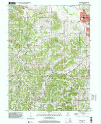 1998 Whitehall2002 Print · USGSThe hill country west of Bloomington is captured in the late 1990s as it spans three county lines. Genealogists and local historians can trace legacy sites from the Owen County Home Cemetery to the small settlements of Whitehall and Hendricksville.
 - 1998 Map of Gosport, 2002 Print
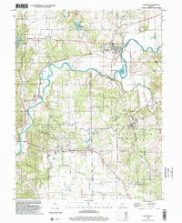 1998 Gosport2002 Print · USGSIndiana stone country and the river valley are captured here in the late nineties, showing the industrial and rural character of the region. Researchers can trace the limestone industry through numerous quarries near Stinesville or locate family sites at Gosport Cem and Shiloh Ch.
 - 1998 Map of Bloomington, 2003 Print
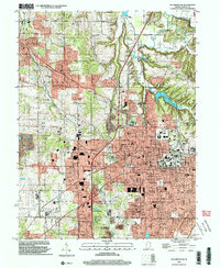 1998 Bloomington2003 Print · USGSMonroe County enters the late twentieth century with its academic and urban core in full view. Genealogists and local historians can trace family locations through Rose Hill Cemetery, identify old school sites like Dyer Jr High Sch, and locate the historic Hunter Switch rail point.
End of results
Showing maps 1-3 of 3
Top cities near Ellettsville
- Bloomington historical maps
- Martinsville historical maps
- Clear Creek historical maps
- Spencer historical maps
- Gosport historical maps
- Paragon historical maps
See more
Frequently asked questions
- What are the different types of historical maps available for Ellettsville?
- What is the oldest map of Ellettsville?
- Where can I purchase historical maps of Ellettsville for my home or office?
- Where can I download high-res historical maps of Ellettsville?
- Are there historical topographic maps available for Ellettsville?
- Is there historical aerial imagery available for Ellettsville?
- Where are historical maps of Ellettsville sourced from?