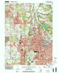
1998 Map of Bloomington
USGS Topo · Published 2003About this map
Bloomington serves as the focal point of this Monroe County study, showcasing the city's significant expansion and institutional footprint at the close of the 20th century. The urban landscape is anchored by the presence of Indiana University Stadium and several educational institutions like Binford Jr High Sch and University Sch. To the northwest, the settlement of Ellettsville and neighborhoods like West Brook Downs represent the growing suburban corridors.
Find a feature on this map
72 named features on this map. Tap any name to fly to it.
Don’t see what you’re looking for? This feature index may not catch every label — zoom into the map to look around manually.
Map Details
Editions of this 1998 Bloomington Map
This is the sole edition of this map. No revisions or reprints were ever made.
Other maps of this area

1908 · Bloomington
USGS Topo · 1:48,000

1910 · Bloomington
USGS Topo · 1:62,500

1942 · Franklin
USGS Topo · 1:125,000

1947 · Allens Creek
USGS Topo · 1:24,000

1947 · Unionville
USGS Topo · 1:24,000

1947 · Gosport
USGS Topo · 1:24,000

1948 · Hindustan
USGS Topo · 1:24,000

1950 · Gosport
USGS Topo · 1:24,000

1953 · Indianapolis
USGS Topo · 1:250,000

1956 · Indianapolis
USGS Topo · 1:250,000