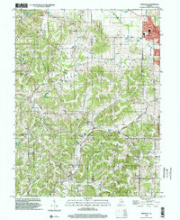
1998 Map of Whitehall
USGS Topo · Published 2002About this map
Ellettsville serves as the primary municipal anchor in this detailed study of the rolling boundary lands between Monroe, Owen, and Greene Counties. The landscape is defined by its deep drainage networks, including Richland Creek and the long valleys of Louden Hollow and Blair Hollow. Cultural and genealogical points of interest are numerous, with several rural houses of worship such as Bethel Ch and Garrison Chapel providing cornerstones for the scattered upland communities. Smaller settlements like Whitehall, Hendricksville, and McVille are captured just as they existed in the late 1990s, set against a backdrop of limestone-rich terrain and timbered ridges. Tracing the numerous family and community burial grounds, from the Hopewell Cem to the Owen County Home Cemetery, offers researchers a clear view of the area's social geography before 21st-century development.
Find a feature on this map
38 named features on this map. Tap any name to fly to it.
Don’t see what you’re looking for? This feature index may not catch every label — zoom into the map to look around manually.
Map Details
Editions of this 1998 Whitehall Map
This is the sole edition of this map. No revisions or reprints were ever made.
Other maps of this area

1908 · Bloomington
USGS Topo · 1:48,000

1908 · Bloomfield
USGS Topo · 1:62,500

1910 · Bloomington
USGS Topo · 1:62,500

1947 · Gosport
USGS Topo · 1:24,000

1950 · Gosport
USGS Topo · 1:24,000

1953 · Indianapolis
USGS Topo · 1:250,000

1956 · Indianapolis
USGS Topo · 1:250,000
1956 · Clear Creek
USGS Topo · 1:24,000

1956 · Freedom
USGS Topo · 1:24,000
1956 · Bloomington
USGS Topo · 1:24,000