1960s Maps of Montgomery County, Indiana
Explore 8 historic maps of Montgomery County from the 1960s. These maps offer a rare glimpse into what life looked like during the 1960s — showing old roads, neighborhoods, homes, and landmarks that have changed or disappeared over time.
Whether you're researching your family's past, planning a metal detecting trip, or studying how Montgomery County's landscape evolved across the 1960s, these high-resolution maps are a powerful tool for exploring the history of this region.
- Focus on a specific era: All maps on this page are from the 1960s, giving you a focused view of this time period.
- See what’s changed: Compare century-old streets, trails, and buildings to today's modern landscape using overlays and satellite layers.
- Research with precision: Use these maps for genealogy, historical research, land use analysis, or educational projects.
- View, download, or print: Maps are fully viewable online in high resolution, and can be downloaded or printed for your own records.
Start exploring Montgomery County's history through authentic maps from the 1960s. This is your window into the past.
Montgomery County, IN maps
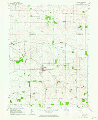
(8)- 1961 Map of Alamo, 1962 Print
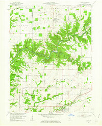 1961 Alamo1962 Print · USGSThe rural landscape of Montgomery County during the early sixties is dominated by the winding path of Sugar Creek and the southern edge of Shades State Park. Researchers can find fascinating relics of local history, from the Deer Mill and its Covered Bridge to the Pennsylvania rail line serving Waveland.3 unique versions available
 - 1961 Map of Shannondale, 1963 Print
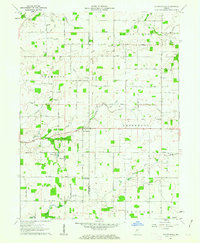 1961 Shannondale1963 Print · USGSCentral Indiana farm country comes into focus in the early sixties, showing the rural landscape before modern expansion. Genealogists can trace family roots through sites like Shannondale, Log Cabin Crossroads, and the Pisgah Cem.2 unique versions available
 - 1962 Map of Indianapolis
 1962 Indianapolis1962 Print · USGSCentral Indiana and the Illinois borderlands are captured here in the early sixties, showing the region's dense rail networks and growing urban centers. Genealogists and historians can locate family-named landmarks and institutions like Crown Hill Cem, Indiana University, and the Indianapolis Motor Speedway.
 - 1962 Map of Colfax, 1963 Print
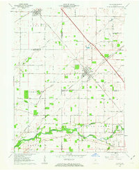 1962 Colfax1963 Print · USGSColfax and the surrounding rural townships are shown here in the early sixties at a peak of mid-century rail activity. Genealogists can trace family connections through numerous local burial sites including Union Cem, Shilo Cem, and Plainview Cem near the banks of Sugar Creek.2 unique versions available
 - 1962 Map of Waynetown, 1964 Print
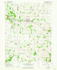 1962 Waynetown1964 Print · USGSThe Montgomery County countryside comes into focus in the early sixties as a network of rail and river commerce. Genealogists can trace family footprints through Masonic Cem, Fruits Cem, and the rural crossroads at Taylor Corner.2 unique versions available
 - 1962 Map of Wingate, 1964 Print
 1962 Wingate1964 Print · USGSIndiana farmland in the early sixties centers on the rail junction at Wingate. Local historians can trace numerous family-named landmarks and rural burial grounds, from Oak Ridge Cem to the Coal Creek Central Sch.2 unique versions available
 - 1963 Map of Bellmore, 1964 Print
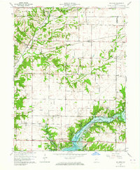 1963 Bellmore1964 Print · USGSEastern Parke County is captured here just as the landscape was transforming with the completion of the Mansfield Reservoir. Researchers can trace old family burial grounds like Lough Cem or follow the rail lines through Guion and Milligan.3 unique versions available
 - 1963 Map of Russellville, 1964 Print
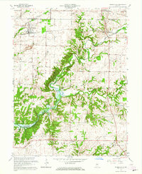 1963 Russellville1964 Print · USGSMid-century Putnam County and Montgomery County meet here in the early 1960s, showing a landscape defined by the Raccoon Creek valley. Genealogists can locate family names at Sutherlin Cem or James Cem and trace the original path of the Baltimore and Ohio railroad through Russellville.2 unique versions available
End of results
Showing maps 1-8 of 8
Top cities of Montgomery County
- Crawfordsville historical maps
- Ladoga historical maps
- Waynetown historical maps
- Darlington historical maps
- Linden historical maps
- New Market historical maps
See more
Frequently asked questions
- What are the different types of historical maps available for Montgomery County?
- What is the oldest map of Montgomery County?
- Where can I purchase historical maps of Montgomery County for my home or office?
- Where can I download high-res historical maps of Montgomery County?
- Are there historical topographic maps available for Montgomery County?
- Is there historical aerial imagery available for Montgomery County?
- Where are historical maps of Montgomery County sourced from?