1940s Maps of Sycamore Ford, Indiana
Explore 1 historic maps of Sycamore Ford from the 1940s. These maps offer a rare glimpse into what life looked like during the 1940s — showing old roads, neighborhoods, homes, and landmarks that have changed or disappeared over time.
Whether you're researching your family's past, planning a metal detecting trip, or studying how Sycamore Ford's landscape evolved across the 1940s, these high-resolution maps are a powerful tool for exploring the history of this region.
- Focus on a specific era: All maps on this page are from the 1940s, giving you a focused view of this time period.
- See what’s changed: Compare century-old streets, trails, and buildings to today's modern landscape using overlays and satellite layers.
- Research with precision: Use these maps for genealogy, historical research, land use analysis, or educational projects.
- View, download, or print: Maps are fully viewable online in high resolution, and can be downloaded or printed for your own records.
Start exploring Sycamore Ford's history through authentic maps from the 1940s. This is your window into the past.
Sycamore Ford, IN maps
(1)- 1949 Map of Alamo
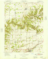 1949 Alamo1949 Print · USGSThe rugged valleys of Montgomery and Parke counties are documented here in the late 1940s, just as the area's natural landmarks gained prominence. Researchers can locate long-standing rural institutions like Liberty Sch, Freedom Ch, and the old grounds of Deer Mill.
End of results
Showing maps 1-1 of 1
Top cities near Sycamore Ford
- Crawfordsville historical maps
- Rockville historical maps
- Veedersburg historical maps
- Waynetown historical maps
- New Market historical maps
- Kingman historical maps
See more
Frequently asked questions
- What are the different types of historical maps available for Sycamore Ford?
- What is the oldest map of Sycamore Ford?
- Where can I purchase historical maps of Sycamore Ford for my home or office?
- Where can I download high-res historical maps of Sycamore Ford?
- Are there historical topographic maps available for Sycamore Ford?
- Is there historical aerial imagery available for Sycamore Ford?
- Where are historical maps of Sycamore Ford sourced from?