1900s (20th Century) Maps of Aberdeen, Indiana
Explore 6 historic maps of Aberdeen from the 1900s (20th Century). These maps offer a rare glimpse into what life looked like during the 1900s — showing old roads, neighborhoods, homes, and landmarks that have changed or disappeared over time.
Whether you're researching your family's past, planning a metal detecting trip, or studying how Aberdeen's landscape evolved across the 1900s, these high-resolution maps are a powerful tool for exploring the history of this region.
- Focus on a specific era: All maps on this page are from the 1900s, giving you a focused view of this time period.
- See what’s changed: Compare century-old streets, trails, and buildings to today's modern landscape using overlays and satellite layers.
- Research with precision: Use these maps for genealogy, historical research, land use analysis, or educational projects.
- View, download, or print: Maps are fully viewable online in high resolution, and can be downloaded or printed for your own records.
Start exploring Aberdeen's history through authentic maps from the 1900s. This is your window into the past.
Aberdeen, IN maps
(6)- 1943 Map of Aberdeen
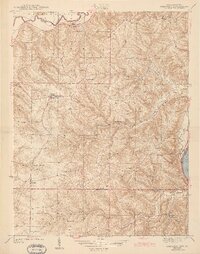 1943 Aberdeen1943 Print · USGSSoutheastern Indiana's river hills are captured here just before mid-century, showing a landscape of ridge-top farms and creek-side settlements. Researchers can locate family landmarks like Gillespie Cem, Bascom Corner, and several schools including Fisher Sch.2 unique versions available
 - 1953 Map of Aberdeen, 1955 Print
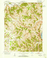 1953 Aberdeen1955 Print · USGSSoutheastern Indiana's rural character is preserved here in the early fifties, showing the upland ridges above the OHIO RIVER. Genealogists and historians can trace family locations near Aberdeen, Bovard Cem, and the Cass-Union Sch along the county lines.2 unique versions available
 - 1956 Map of Louisville, 1971 Print
 1956 Louisville1971 Print · USGSThe Ohio River valley and the Kentucky Bluegrass are captured here during a period of rapid mid-century growth and industrial activity. Genealogists and historians can trace rail-centered towns and military land use at Fort Knox and the Jefferson Proving Ground.2 unique versions available
 - 1964 Map of Louisville
 1964 Louisville1964 Print · USGSThe Ohio River valley and Kentucky Bluegrass are captured in the mid-1960s, showing a region balanced between industrial growth and its agrarian roots. Genealogists and historians can trace the development of county seats like Shelbyville and Paris, or locate established institutions such as Georgetown College and Bernheim Forest.
 - 1965 Map of Aberdeen, 1967 Print
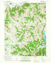 1965 Aberdeen1967 Print · USGSThe hills of Ohio and Switzerland counties are captured here in the mid-1960s, showing a landscape of high ridges and narrow creek bottoms. Genealogists can trace family landmarks and local centers like Aberdeen, Salem Ch, and the Grant Brothers Cem.3 unique versions available
 - 1986 Map of Falmouth
 1986 Falmouth1986 Print · USGSNorthern Kentucky and the Ohio River valley are shown here in the mid-1980s, highlighting the region's complex river-and-rail geography. Genealogists and researchers can trace the roads connecting Big Bone Lick, Zion Church, and river towns like Falmouth and Augusta.2 unique versions available
End of results
Showing maps 1-6 of 6
Top cities near Aberdeen
- Burlington historical maps
- Lawrenceburg historical maps
- Greendale historical maps
- Carrollton historical maps
- Aurora historical maps
- Sparta historical maps
See more
Frequently asked questions
- What are the different types of historical maps available for Aberdeen?
- What is the oldest map of Aberdeen?
- Where can I purchase historical maps of Aberdeen for my home or office?
- Where can I download high-res historical maps of Aberdeen?
- Are there historical topographic maps available for Aberdeen?
- Is there historical aerial imagery available for Aberdeen?
- Where are historical maps of Aberdeen sourced from?