
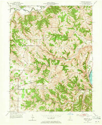
1953 Map of Aberdeen
USGS Topo · Published 1955About this map
Laughery Creek and the Ohio River frame a deeply dissected landscape of ridges and hollows in this mid-century survey of the Indiana-Kentucky borderlands. Small rural settlements and crossroad hamlets like Aberdeen, Hartford, and Pate serve as the primary hubs for a dispersed agricultural population. The map meticulously documents the social fabric of the era through its numerous country churches and cemeteries, such as Mt Carmel Ch, Sycamore Ch, and Bovard Cem.
Find a feature on this map
48 named features on this map. Tap any name to fly to it.
Don’t see what you’re looking for? This feature index may not catch every label — zoom into the map to look around manually.
Map Details
Editions of this 1953 Aberdeen Map
2 editions found
Other maps of this area

1915 · Lawrenceburg
USGS Topo · 1:48,000

1928 · Lawrenceburg
USGS Topo · 1:62,500

1932 · Lawrenceburg
USGS Topo · 1:62,500

1943 · Florence
USGS Topo · 1:24,000

1943 · Aberdeen
USGS Topo · 1:24,000

1943 · Aurora
USGS Topo · 1:24,000

1943 · Vevay North
USGS Topo · 1:24,000

1943 · Rising Sun
USGS Topo · 1:24,000

1943 · Lawrenceburg
USGS Topo · 1:24,000

1943 · Patriot
USGS Topo · 1:24,000