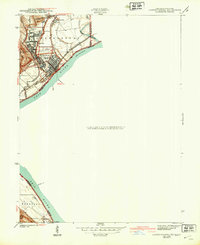
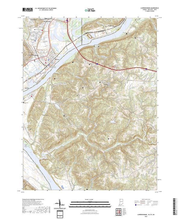
1943 Map of Lawrenceburg
USGS Topo · Published 1943About this map
The convergence of the Miami River and the Ohio River dominates this mid-century survey, illustrating a dense network of river-town settlements along the Indiana, Kentucky, and Ohio border. Lawrenceburg serves as the focal point, flanked by distinct districts such as Oldtown, Newtown, and the neighboring community of Greendale. The industrial and transportation identity of the era is evident in the heavy presence of the Baltimore and Ohio and New York Central railroads which parallel the riverbanks. Beyond the urban centers, the landscape transitions into the hills of French Hollow and the drainage of Tanners Creek. Local landmarks like the Fair Grounds and the extensive Greendale Cem provide specific points of interest for genealogists and local historians, while the inclusion of Laughery I in the river channel reveals the hydrologic character of the Ohio before modern alterations.
Find a feature on this map
31 named features on this map. Tap any name to fly to it.
Don’t see what you’re looking for? This feature index may not catch every label — zoom into the map to look around manually.
Map Details
Editions of this 1943 Lawrenceburg Map
This is the sole edition of this map. No revisions or reprints were ever made.
Historical Maps of Burlington Through Time
10 maps found

1915 Lawrenceburg
Dearborn County, IN

1928 Lawrenceburg
Dearborn County, IN
1932 Lawrenceburg
Dearborn County, IN
1943 Lawrenceburg
Dearborn County, IN
1981 Lawrenceburg
Dearborn County, IN
2010 Lawrenceburg
Dearborn County, IN
2013 Lawrenceburg
Dearborn County, IN
2016 Lawrenceburg
Dearborn County, IN
2019 Lawrenceburg
Dearborn County, IN
2022 Lawrenceburg
Dearborn County, IN
Featured Locations
- Burlington, KY
- Aurora, Center Township
- Greendale, Lawrenceburg Township
- Lawrenceburg, Lawrenceburg Township
- Finney, Miami Township