Old Maps of Boone County, Kentucky
Explore 125 old maps of Boone County, spanning from 1914 to today. These high-resolution historic maps reveal how streets, neighborhoods, landmarks, and natural features evolved over time — perfect for genealogy, metal detecting, research, and local history exploration.
What you can do with these maps:
- See how Boone County changed over time: Compare historical maps to modern-day views to trace roads, homesites, rail lines & more.
- View detailed metadata: Each map includes creators, publishers, year, scale, and archive source.
- Overlay maps with satellite & LiDAR: Visualize the past alongside modern tools to explore terrain & human change.
- Trusted historical sources: Maps sourced from the USGS, Library of Congress, and other archives.
- Access maps your way: View online, download high-res files, or order prints for personal or research use.
Start exploring old maps of Boone County to uncover forgotten places, hidden landmarks, and the deep history beneath your feet.
Boone County, KY maps
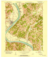
(125)- 1914 Map of West Cincinnati
 1914 West Cincinnati1914 Print · USGSCincinnati and the Ohio River valley appear here in a period of intense industrial growth and suburban expansion just before the First World War. Researchers can trace the dense rail networks of the Chesapeake and Ohio or locate early institutions like the Ohio Military Institute and Spring Grove Cemetery.4 unique versions available
 - 1915 Map of Lawrenceburg
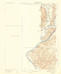
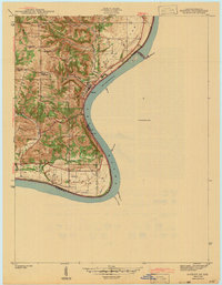
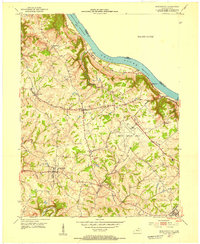
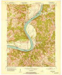
 1915 Lawrenceburg1915 Print · USGSThe tri-state river junction between Indiana, Ohio, and Kentucky is captured just before the first World War during a peak era of rail expansion. Researchers can trace the legacy of local transit through Simmonson Station, the Suspension Bridge, and the tracks of the Electric line.
 - 1928 Map of Lawrenceburg, 1962 Print
 1928 Lawrenceburg1962 Print · USGSThe tri-state river valley at the end of the Roaring Twenties shows a landscape shaped by the Ohio River and bustling rail junctions. Researchers can trace historic ferries like the Lawrenceburg Ferry and find family-named landmarks like Commissary Corner or the Bullittsburg Ch.
 - 1932 Map of Lawrenceburg
 1932 Lawrenceburg1932 Print · USGSThe tri-state confluence of Indiana, Ohio, and Kentucky comes alive in this early 1930s survey of the river valleys. Genealogists can trace family roots through rural landmarks like Eighteenmile House, Bullittsville Ch, and the Woolper Sch.3 unique versions available
 - 1943 Map of Aberdeen
 1943 Aberdeen1943 Print · USGSSoutheastern Indiana's river hills are captured here just before mid-century, showing a landscape of ridge-top farms and creek-side settlements. Researchers can locate family landmarks like Gillespie Cem, Bascom Corner, and several schools including Fisher Sch.2 unique versions available
 - 1943 Map of Aurora
 1943 Aurora1943 Print · USGSDearborn County as it appeared in the early 1940s shows a landscape where river commerce and rail lines defined the growth of Aurora. Genealogists and local historians can trace rural schoolhouses like Worley Sch, country churches such as Mt Tabor Ch, and the original Baltimore and Ohio rail route.2 unique versions available
 - 1943 Map of Rising Sun
 1943 Rising Sun1943 Print · USGSThe Ohio River valley in the early 1940s was a landscape defined by riverside settlements and the steady work of river navigation. Genealogists can trace family histories through local landmarks like German Cem, North Landing, and the Laughery Club.
 - 1943 Map of Hooven
 1943 Hooven1943 Print · USGSThe Indiana-Ohio borderlands come into focus in the early 1940s, showing a landscape defined by the Whitewater R and the New York Central rail line. Researchers can locate early family sites near Sugar Ridge Cem, the Full Gospel Mission, and the State Line Monument.
 - 1943 Map of Lawrenceburg
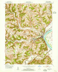
 1943 Lawrenceburg1943 Print · USGSThe Indiana-Kentucky-Ohio tri-state border comes alive in this wartime-era survey of the Ohio River valley. Researchers can trace the rail-side growth of Lawrenceburg and Greendale or locate family plots in the Greendale Cem.
 - 1943 Map of Patriot
 1943 Patriot1943 Print · USGSThe river town of Patriot and the winding Indiana shoreline appear here as they were in the early 1940s. Genealogists can trace family names through several rural landmarks, including Mc Nutt Cem, Wigal Cem, and Concord Ch.
 - 1950 Map of Union, 1952 Print
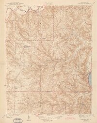
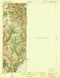
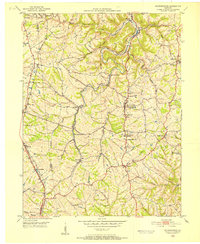
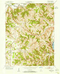
 1950 Union1952 Print · USGSBoone County's rolling landscape is captured here in the early fifties, showing a rural world of crossroads hamlets and family-named landmarks. You can trace the community life of the era through Sugartit, the New Haven Sch, and old burial grounds like Rice Cem.
 - 1950 Map of Independence, 1952 Print
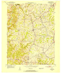
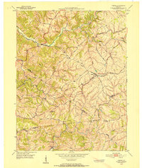
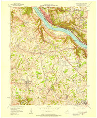
 1950 Independence1952 Print · USGSNorthern Kentucky in the early postwar years reveals a landscape of ridge-top farms and creek-bottom rail lines. Researchers can trace family sites near Independence or locate rural landmarks like New Banklick Ch and Independence Sta.
 - 1950 Map of Verona, 1952 Print
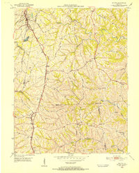
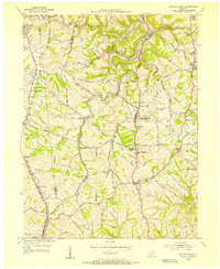
 1950 Verona1952 Print · USGSNorthern Kentucky’s rolling hills come alive in this mid-century survey, showcasing the rural intersections where Boone, Gallatin, and Grant Counties meet. Genealogists can trace family names at St Patricks Cem or locate the old rail-stop at Zion Station.
 - 1950 Map of Walton, 1952 Print
 1950 Walton1952 Print · USGSNorthern Kentucky's rail-dependent landscape is captured here at mid-century, centered on the busy junction at Walton. Genealogists can trace family heritage through dozens of small burial grounds like Cook-Smith Cem and Grayson Cem or rural stops at Bracht Station.
 - 1950 Map of Covington, 1953 Print
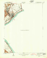
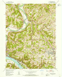
 1950 Covington1953 Print · USGSNorthern Kentucky's riverfront and southern suburbs are captured here at the mid-century mark as neighborhoods expanded along the Dixie Highway. Genealogists and historians can trace family plots in Highland Cem or locate community landmarks like the Villa Madonna and Dixie Heights High Sch.
 - 1951 Map of Burlington, 1953 Print
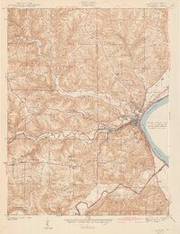
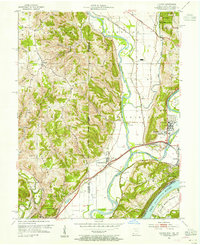
 1951 Burlington1953 Print · USGSBoone County and the Ohio River shoreline appear here in the early fifties, showing the region as it transitioned into a major aviation hub. Genealogists can locate family burial sites like I O O F Cem and Watts Cem, or trace early roads near Hebron and Florence.
 - 1951 Map of Rising Sun, 1953 Print
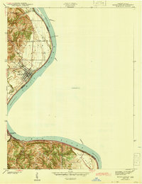
 1951 Rising Sun1953 Print · USGSThe Ohio River valley at the start of the 1950s reveals a landscape of fertile bottomlands and established river towns. Researchers can trace the heritage of Rising Sun and Rabbit Hash while locating family sites like East Bend Ch and the Stephens Cem.
 - 1951 Map of Patriot, 1953 Print
 1951 Patriot1953 Print · USGSThe Indiana-Kentucky border along the Ohio River is captured here in the early fifties, showing a landscape of fertile river bottoms and upland farms. Genealogists can trace family roots at Patriot or locate rural landmarks like Searcy Crossroads, Concord Ch, and McNutt Cem.
 - 1953 Map of Aberdeen, 1955 Print
 1953 Aberdeen1955 Print · USGSSoutheastern Indiana's rural character is preserved here in the early fifties, showing the upland ridges above the OHIO RIVER. Genealogists and historians can trace family locations near Aberdeen, Bovard Cem, and the Cass-Union Sch along the county lines.2 unique versions available
 - 1953 Map of Aurora, 1955 Print
 1953 Aurora1955 Print · USGSThe Ohio River valley near Aurora was a bustling corridor of rail and river commerce in the early 1950s. Genealogists and local historians can locate early landmarks such as the Riverview Cemetery and trace the paths of the Baltimore and Ohio railroad through Wilmington.2 unique versions available
 - 1953 Map of Cincinnati, 1965 Print
 1953 Cincinnati1965 Print · USGSThe Ohio River valley and the industrial heartland of Indiana and Ohio are captured here during the mid-century peak of rail and river commerce. Genealogists and historians can trace connections between Cincinnati and outlying military sites like Camp Atterbury and Bakalar AFB.3 unique versions available
 - 1954 Map of Hooven, 1955 Print
 1954 Hooven1955 Print · USGSThe tri-state confluence of the Whitewater, Miami, and Ohio Rivers was a busy industrial and transit corridor in the 1950s. You can trace early family sites at Sugar Ridge Cem, follow the New York Central Railroad through Valley Junction, or locate the mid-century Gas Refinery.3 unique versions available
 - 1954 Map of Addyston, 1955 Print
 1954 Addyston1955 Print · USGSThe Ohio River valley and its industrial corridors are captured here in the mid-fifties as the Cincinnati suburbs began to crest the western hills. Genealogists and historians can trace the paths of the Baltimore and Ohio railroad through Addyston, North Bend, and landmarks like Bethel Cem.
 - 1955 Map of Burlington, 1956 Print
 1955 Burlington1956 Print · USGSThe Ohio River valley in the mid-fifties reveals a bustling industrial riverfront alongside quiet Kentucky hillsides. Genealogists and historians can trace family cemeteries like Chambers Cem, locate the Anderson Ferry, and see the early Greater Cincinnati Airport.
 - 1955 Map of Independence, 1956 Print
 1955 Independence1956 Print · USGSKenton County communities like Independence and Florence are shown in the mid-fifties as they balanced rural tradition with post-war growth. Researchers can trace family history through several local landmarks, including Independence Cem, Eggleston Ch, and the Simon Kenton High Sch.
Showing maps 1-25 of 125
Top cities of Boone County
Frequently asked questions
- What are the different types of historical maps available for Boone County?
- What is the oldest map of Boone County?
- Where can I purchase historical maps of Boone County for my home or office?
- Where can I download high-res historical maps of Boone County?
- Are there historical topographic maps available for Boone County?
- Is there historical aerial imagery available for Boone County?
- Where are historical maps of Boone County sourced from?