1960s Maps of Boone County, Kentucky
Explore 14 historic maps of Boone County from the 1960s. These maps offer a rare glimpse into what life looked like during the 1960s — showing old roads, neighborhoods, homes, and landmarks that have changed or disappeared over time.
Whether you're researching your family's past, planning a metal detecting trip, or studying how Boone County's landscape evolved across the 1960s, these high-resolution maps are a powerful tool for exploring the history of this region.
- Focus on a specific era: All maps on this page are from the 1960s, giving you a focused view of this time period.
- See what’s changed: Compare century-old streets, trails, and buildings to today's modern landscape using overlays and satellite layers.
- Research with precision: Use these maps for genealogy, historical research, land use analysis, or educational projects.
- View, download, or print: Maps are fully viewable online in high resolution, and can be downloaded or printed for your own records.
Start exploring Boone County's history through authentic maps from the 1960s. This is your window into the past.
Boone County, KY maps
(14)- 1960 Map of Addyston, 1963 Print
 1960 Addyston1963 Print · USGSGreater Cincinnati's western riverfront is captured here in the early sixties, showing the industrial pulse of Addyston and North Bend along the river. Genealogists can trace family names at the Bridgetown Cemetery or locate schools like Oak Hill High Sch.3 unique versions available
 - 1961 Map of Verona, 1962 Print
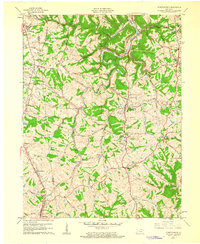
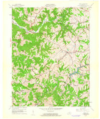 1961 Verona1962 Print · USGSNorthern Kentucky's ridge-and-hollow farm country is captured here in the early sixties as the railroad era still shaped local life. Genealogists and historians can trace family land via Powers Cem, St Patricks Cem, and the old rail siding at Zion Station.
 - 1961 Map of Walton, 1962 Print
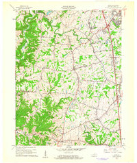
 1961 Walton1962 Print · USGSNorthern Kentucky's ridge-and-hollow farming country is captured here in the early sixties at the junction of three counties. Genealogists can trace family lines through numerous rural burial sites like Byland Cem and Fishback Cem or locate the community hubs of Piner and Crittenden.2 unique versions available
 - 1961 Map of Union, 1962 Print
 1961 Union1962 Print · USGSBoone County at the start of the sixties showcases a blend of growing suburban hubs and traditional rural crossroads. Researchers can trace family roots through historic sites like Big Bone Ch, the oddly-named Sugartit, and the small community of Beaverlick.2 unique versions available
 - 1961 Map of Independence, 1962 Print
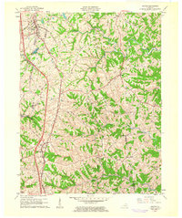
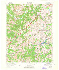
 1961 Independence1962 Print · USGSKenton and Boone counties are shown here in the early sixties, as suburban expansion began to reach southward into traditional Kentucky farmland. Trace family roots and local history at Kenton High Sch, Independence Cem, or the Drive-in Theater near Florence.2 unique versions available
 - 1961 Map of Rising Sun, 1963 Print
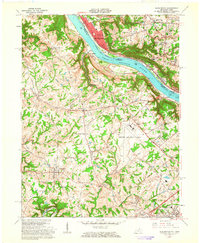
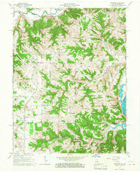
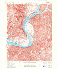
 1961 Rising Sun1963 Print · USGSThe Ohio River valley at the start of the 1960s shows a landscape of fertile bottomlands and storied river landings. Genealogists can trace family names at Rabbit Hash, Cedar Hedge Cem, and the historic Big Bone Lick State Park.2 unique versions available
 - 1961 Map of Burlington, 1963 Print
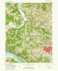
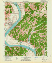
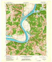
 1961 Burlington1963 Print · USGSNorthern Kentucky and the Cincinnati riverfront meet in the early sixties during a period of rapid suburban and industrial growth. Genealogists and local historians can trace family burial sites like the Col Abraham Depew Grave and river crossings like the Anderson Ferry.3 unique versions available
 - 1961 Map of Covington, 1963 Print
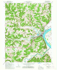
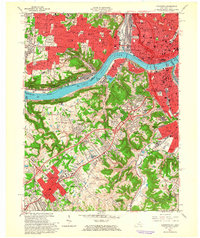 1961 Covington1963 Print · USGSThe Ohio River corridor comes alive in the early sixties as industrial centers and hillside neighborhoods bridge the state line. Genealogists and historians can trace St Josephs Cemetery, find the St Johns Orphanage, or locate the Anderson Ferry crossing.3 unique versions available
 - 1961 Map of Patriot, 1963 Print
 1961 Patriot1963 Print · USGSThe Ohio River oxbow between Indiana and Kentucky is documented here in the early 1960s, showing the fertile bottomlands and rural ridge settlements. Genealogists can locate numerous family burial sites such as Warner Cem and Conley Cem, or trace early congregations at Concord Ch.
 - 1964 Map of Louisville
 1964 Louisville1964 Print · USGSThe Ohio River valley and Kentucky Bluegrass are captured in the mid-1960s, showing a region balanced between industrial growth and its agrarian roots. Genealogists and historians can trace the development of county seats like Shelbyville and Paris, or locate established institutions such as Georgetown College and Bernheim Forest.
 - 1965 Map of Aberdeen, 1967 Print
 1965 Aberdeen1967 Print · USGSThe hills of Ohio and Switzerland counties are captured here in the mid-1960s, showing a landscape of high ridges and narrow creek bottoms. Genealogists can trace family landmarks and local centers like Aberdeen, Salem Ch, and the Grant Brothers Cem.3 unique versions available
 - 1966 Map of Aurora, 1967 Print
 1966 Aurora1967 Print · USGSThe Ohio River valley and the busy Baltimore and Ohio rail line dominate the Dearborn County landscape during the mid-sixties. Genealogists and local historians can locate the old community of Wilmington, the industrial docks at Aurora, and historic sites like Mt Sinai Ch.
 - 1969 Map of Verona, 1971 Print
 1969 Verona1971 Print · USGSNorthern Kentucky at the end of the 1960s shows a landscape of rail-connected hamlets and winding creek valleys. Trace local history through the Beaverlick Sch, the Louisville & Nashville RR corridor, and Bullock Pen Lake.
 - 1969 Map of Patriot, 1971 Print
 1969 Patriot1971 Print · USGSThe Ohio River dominates this 1960s borderland survey of Switzerland County, Indiana, and northern Kentucky. Genealogists can trace family roots through riverside bottoms and rural landmarks like Patriot, Warner Cem, and Sugar Creek.2 unique versions available
End of results
Showing maps 1-14 of 14
Top cities of Boone County
Frequently asked questions
- What are the different types of historical maps available for Boone County?
- What is the oldest map of Boone County?
- Where can I purchase historical maps of Boone County for my home or office?
- Where can I download high-res historical maps of Boone County?
- Are there historical topographic maps available for Boone County?
- Is there historical aerial imagery available for Boone County?
- Where are historical maps of Boone County sourced from?