1970s Maps of Bloomingdale, Indiana
Explore 2 historic maps of Bloomingdale from the 1970s. These maps offer a rare glimpse into what life looked like during the 1970s — showing old roads, neighborhoods, homes, and landmarks that have changed or disappeared over time.
Whether you're researching your family's past, planning a metal detecting trip, or studying how Bloomingdale's landscape evolved across the 1970s, these high-resolution maps are a powerful tool for exploring the history of this region.
- Focus on a specific era: All maps on this page are from the 1970s, giving you a focused view of this time period.
- See what’s changed: Compare century-old streets, trails, and buildings to today's modern landscape using overlays and satellite layers.
- Research with precision: Use these maps for genealogy, historical research, land use analysis, or educational projects.
- View, download, or print: Maps are fully viewable online in high resolution, and can be downloaded or printed for your own records.
Start exploring Bloomingdale's history through authentic maps from the 1970s. This is your window into the past.
Bloomingdale, IN maps
(2)- 1978 Map of Rockville
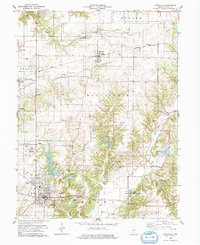 1978 Rockville1978 Print · USGSParke County in the late seventies showcases a landscape of historic river crossings and established rail towns. Genealogists and historians can trace family roots through numerous sites like Billie Creek Village, Bethany Ch, and the Adams Covered Bridge.2 unique versions available
 - 1978 Map of Montezuma
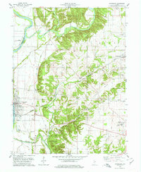 1978 Montezuma1978 Print · USGSThe Wabash River valley in the late 1970s reveals a blend of traditional Indiana rural life and heavy industrial enterprise. Genealogists and historians can trace family burial sites like Linebarger Chapel Cem and industrial landmarks such as the kilns in Bloomingdale.
End of results
Showing maps 1-2 of 2
Top cities near Bloomingdale
- Clinton historical maps
- Rockville historical maps
- Eugene historical maps
- Highland historical maps
- Fairview Park historical maps
- Montezuma historical maps
See more
Frequently asked questions
- What are the different types of historical maps available for Bloomingdale?
- What is the oldest map of Bloomingdale?
- Where can I purchase historical maps of Bloomingdale for my home or office?
- Where can I download high-res historical maps of Bloomingdale?
- Are there historical topographic maps available for Bloomingdale?
- Is there historical aerial imagery available for Bloomingdale?
- Where are historical maps of Bloomingdale sourced from?