1970s Maps of Smockville, Indiana
Explore 1 historic maps of Smockville from the 1970s. These maps offer a rare glimpse into what life looked like during the 1970s — showing old roads, neighborhoods, homes, and landmarks that have changed or disappeared over time.
Whether you're researching your family's past, planning a metal detecting trip, or studying how Smockville's landscape evolved across the 1970s, these high-resolution maps are a powerful tool for exploring the history of this region.
- Focus on a specific era: All maps on this page are from the 1970s, giving you a focused view of this time period.
- See what’s changed: Compare century-old streets, trails, and buildings to today's modern landscape using overlays and satellite layers.
- Research with precision: Use these maps for genealogy, historical research, land use analysis, or educational projects.
- View, download, or print: Maps are fully viewable online in high resolution, and can be downloaded or printed for your own records.
Start exploring Smockville's history through authentic maps from the 1970s. This is your window into the past.
Smockville, IN maps
(1)- 1978 Map of Catlin, 1979 Print
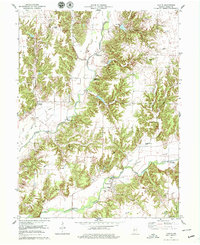 1978 Catlin1979 Print · USGSParke County’s river valleys were defined by their timbered crossings in the late 1970s. Genealogists and historians can trace the numerous spans like Nevins Covered Bridge and Conleys Ford Covered Bridge near the settlement of Bridgeton.2 unique versions available
End of results
Showing maps 1-1 of 1
Top cities near Smockville
- Terre Haute historical maps
- Brazil historical maps
- Rockville historical maps
- Seelyville historical maps
- Rosedale historical maps
- Knightsville historical maps
See more
Frequently asked questions
- What are the different types of historical maps available for Smockville?
- What is the oldest map of Smockville?
- Where can I purchase historical maps of Smockville for my home or office?
- Where can I download high-res historical maps of Smockville?
- Are there historical topographic maps available for Smockville?
- Is there historical aerial imagery available for Smockville?
- Where are historical maps of Smockville sourced from?