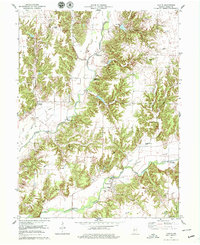
1978 Map of Catlin
USGS Topo · Published 1979About this map
Big Raccoon Creek and Little Raccoon Creek converge in this portion of Parke County, defining a landscape marked by numerous historic crossings. The area is notable for its unusually high density of timbered spans, including Crooks Covered Bridge, McAllisters Covered Bridge, and Neet Covered Bridge, reflecting a preserved local tradition of river engineering. The settlement of Bridgeton sits along the southern waters of the Raccoon, featuring the Clear Run Cem and a Township Sch. To the west, the former path of the Old Railroad Grade passes near Catlin, while industrial history is evidenced by a Strip Mine and a Pumping Sta. From the high point of Snow Hill to the flat reaches of Pleasant Valley, the survey illustrates a rural community tied to its waterways and agricultural townships.
Find a feature on this map
34 named features on this map. Tap any name to fly to it.
Don’t see what you’re looking for? This feature index may not catch every label — zoom into the map to look around manually.
Map Details
Editions of this 1978 Catlin Map
2 editions found
Other maps of this area

1950 · Rosedale
USGS Topo · 1:24,000

1950 · Brazil East
USGS Topo · 1:24,000

1950 · Brazil West
USGS Topo · 1:24,000

1951 · Mecca
USGS Topo · 1:24,000

1951 · Mansfield
USGS Topo · 1:24,000

1952 · Catlin
USGS Topo · 1:24,000

1953 · Indianapolis
USGS Topo · 1:250,000

1955 · Rockville
USGS Topo · 1:24,000

1955 · Montezuma
USGS Topo · 1:24,000

1956 · Indianapolis
USGS Topo · 1:250,000