
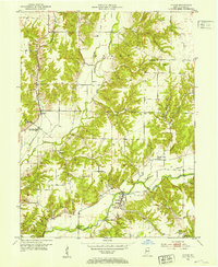
1952 Map of Catlin
USGS Topo · Published 1953About this map
The community of Bridgeton anchors the southern portion of this Parke County study, where a concentration of social and civic markers includes the High Sch and Clear Run Cem. The landscape is defined by the winding course of Big Raccoon Creek, which is spanned by the Jeffries Ford Bridge near the southwest corner. Transportation and industry are central to the area's development, evidenced by the Pennsylvania railroad line passing through Catlin and the presence of a Pumping Sta (Abandoned) nearby. Land use in the early 1950s reflects a mix of traditional agriculture and resource extraction, with several Strip Mine operations and a Gravel Pit scattered among the smaller settlements of Minshall and Snow Hill. Local family history is preserved in small burial grounds like Hartmans Cem and Brunot Cem, which remain tucked away from the main thoroughfares.
Find a feature on this map
35 named features on this map. Tap any name to fly to it.
Don’t see what you’re looking for? This feature index may not catch every label — zoom into the map to look around manually.
Map Details
Editions of this 1952 Catlin Map
2 editions found
Other maps of this area

1950 · Rosedale
USGS Topo · 1:24,000

1950 · Brazil East
USGS Topo · 1:24,000

1950 · Brazil West
USGS Topo · 1:24,000

1951 · Mecca
USGS Topo · 1:24,000

1951 · Mansfield
USGS Topo · 1:24,000

1953 · Indianapolis
USGS Topo · 1:250,000

1955 · Rockville
USGS Topo · 1:24,000

1955 · Montezuma
USGS Topo · 1:24,000

1956 · Indianapolis
USGS Topo · 1:250,000

1957 · Indianapolis
USGS Topo · 1:250,000