
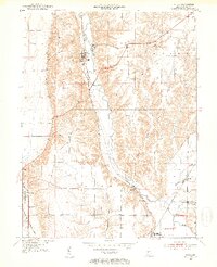
1951 Map of Mecca
USGS Topo · Published 1953About this map
The brick-making village of Mecca and its industrial Kilns sit at the heart of this mid-century Indiana landscape, where the Baltimore and Ohio railroad corridor follows the winding course of Raccoon Creek. Further south, the town of Rosedale serves as a junction point where the Pennsylvania rail line crosses through the township of Florida. The topography is defined by the sharp dissection of the uplands by Rock Run and Weisner Creek, creating a complex network of ridges and ravines that dictated the placement of early rural landmarks. Genealogists can find several family and community burial grounds, including Hixon Cem and Mt Pleasant Cem, while the local education and social history is represented by the Roseville Sch and country congregations like Bethel Ch and Friendly Grove Ch.
Find a feature on this map
27 named features on this map. Tap any name to fly to it.
Don’t see what you’re looking for? This feature index may not catch every label — zoom into the map to look around manually.
Map Details
Editions of this 1951 Mecca Map
2 editions found
Other maps of this area

1950 · Rosedale
USGS Topo · 1:24,000

1950 · Brazil West
USGS Topo · 1:24,000

1950 · New Goshen
USGS Topo · 1:24,000

1951 · Clinton
USGS Topo · 1:24,000

1952 · Catlin
USGS Topo · 1:24,000

1953 · Indianapolis
USGS Topo · 1:250,000

1955 · Rockville
USGS Topo · 1:24,000

1955 · Montezuma
USGS Topo · 1:24,000

1955 · Dana
USGS Topo · 1:24,000

1956 · Indianapolis
USGS Topo · 1:250,000