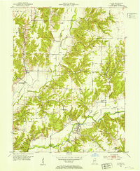
1952 Map of Catlin
USGS Topo · Published 1973About this map
Bridgeton and its surrounding countryside reflect a mid-century Indiana landscape defined by its waterways and small rural communities. The winding course of Raccoon Creek and Little Raccoon Creek anchors the region, while the Pennsylvania railroad corridor connects the village of Catlin to the broader industrial network. Local life is documented through numerous community landmarks, including the High Sch and Clear Run Cem in Bridgeton, as well as several country churches such as New Discovery Ch and Mt Olivet Ch. Significant industrial activity is evident at the Strip Mine near Minshall and a nearby Gravel Pit. Notable infrastructure from the era includes the Jeffries Ford Bridge and a Pumping Sta (Abandoned) located south of Catlin. The map provides a detailed view of family-named cemeteries like Hartmans Cem and Hatfield Cem, which are vital markers for local genealogy and history.
Find a feature on this map
33 named features on this map. Tap any name to fly to it.
Don’t see what you’re looking for? This feature index may not catch every label — zoom into the map to look around manually.
Map Details
Editions of this 1952 Catlin Map
2 editions found
Other maps of this area

1950 · Rosedale
USGS Topo · 1:24,000

1950 · Brazil East
USGS Topo · 1:24,000

1950 · Brazil West
USGS Topo · 1:24,000

1951 · Mecca
USGS Topo · 1:24,000

1951 · Mansfield
USGS Topo · 1:24,000

1952 · Catlin
USGS Topo · 1:24,000

1953 · Indianapolis
USGS Topo · 1:250,000

1955 · Rockville
USGS Topo · 1:24,000

1955 · Montezuma
USGS Topo · 1:24,000

1956 · Indianapolis
USGS Topo · 1:250,000