1990s Maps of Burns Harbor, Indiana
Explore 4 historic maps of Burns Harbor from the 1990s. These maps offer a rare glimpse into what life looked like during the 1990s — showing old roads, neighborhoods, homes, and landmarks that have changed or disappeared over time.
Whether you're researching your family's past, planning a metal detecting trip, or studying how Burns Harbor's landscape evolved across the 1990s, these high-resolution maps are a powerful tool for exploring the history of this region.
- Focus on a specific era: All maps on this page are from the 1990s, giving you a focused view of this time period.
- See what’s changed: Compare century-old streets, trails, and buildings to today's modern landscape using overlays and satellite layers.
- Research with precision: Use these maps for genealogy, historical research, land use analysis, or educational projects.
- View, download, or print: Maps are fully viewable online in high resolution, and can be downloaded or printed for your own records.
Start exploring Burns Harbor's history through authentic maps from the 1990s. This is your window into the past.
Burns Harbor, IN maps
(4)- 1991 Map of Dune Acres, 1992 Print
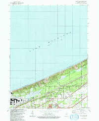 1991 Dune Acres1992 Print · USGSCoastal Porter County in the early 1990s showcases the intersection of protected lakefront and industrial growth. Genealogists and local historians can locate Baily Cem, the hamlet of Furnessville, and early transport markers like Dune Acres Station.
 - 1991 Map of Chesterton, 1992 Print
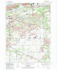
 1991 Chesterton1992 Print · USGSIn the early nineties, the lakefront communities of Northwest Indiana were defined by their proximity to the dunes and heavy rail lines. Genealogists and historians can trace family sites at Augsburg Cem & Ch, the Old Indian Treaty Boundary, and the historic settlement of Crocker.
 - 1991 Map of Ogden Dunes, 1992 Print
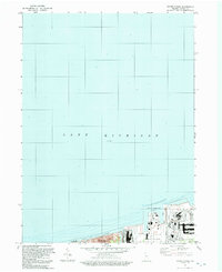 1991 Ogden Dunes1992 Print · USGSCoastal Indiana in the early nineties showcases a transition between industrial maritime hubs and protected dunes. Researchers can trace the boundaries of the Indiana Dunes National Lakeshore and the shipping infrastructure at the Port of Indiana.
 - 1992 Map of Portage
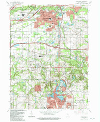
 1992 Portage1992 Print · USGSNear the Indiana shoreline in the early 1990s, the landscape of Portage shows a dense mesh of heavy industry and suburban expansion. Genealogists can locate several local burial sites such as Calvary Cemetery and McCool Cem, alongside the rails of the CONRAIL and CSX TRANSPORTATION.
End of results
Showing maps 1-4 of 4
Top cities near Burns Harbor
- Gary historical maps
- Portage historical maps
- Valparaiso historical maps
- Michigan City historical maps
- Merrillville historical maps
- Hobart historical maps
See more
Top neighborhoods of Burns Harbor
Frequently asked questions
- What are the different types of historical maps available for Burns Harbor?
- What is the oldest map of Burns Harbor?
- Where can I purchase historical maps of Burns Harbor for my home or office?
- Where can I download high-res historical maps of Burns Harbor?
- Are there historical topographic maps available for Burns Harbor?
- Is there historical aerial imagery available for Burns Harbor?
- Where are historical maps of Burns Harbor sourced from?