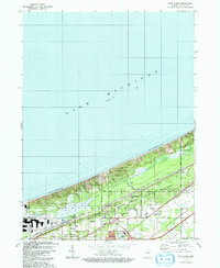
1991 Map of Dune Acres
USGS Topo · Published 1992About this map
Lake Michigan borders a complex landscape of conservation and industrial activity in the early 1990s. The northern shoreline is dominated by the Indiana Dunes State Park and the Indiana Dunes National Lakeshore, protecting significant natural landmarks like Mt Tom and the ecological preserve of Cowles Bog. Residential enclaves such as Dune Acres and Beverly Shores sit directly against the dunes, while the inland southern portion shows the more established grid of Porter and Chesterton. The map documents a transition from these protected natural spaces to the heavy infrastructure of Burns Harbor to the west. Local history is anchored by sites like Baily Cem and Burstrom Cem, while the regional economy is reflected in features ranging from an Amusement Park to the Dune Acres Station.
Find a feature on this map
29 named features on this map. Tap any name to fly to it.
Don’t see what you’re looking for? This feature index may not catch every label — zoom into the map to look around manually.
Map Details
Editions of this 1991 Dune Acres Map
This is the sole edition of this map. No revisions or reprints were ever made.
Other maps of this area

1934 · Porter
USGS Topo · 1:48,000

1940 · Porter
USGS Topo · 1:62,500

1953 · Garyton
USGS Topo · 1:24,000

1953 · Westville
USGS Topo · 1:24,000

1953 · Ogden Dunes
USGS Topo · 1:24,000

1953 · Chesterton
USGS Topo · 1:24,000

1953 · Dune Acres
USGS Topo · 1:24,000

1953 · Michigan City West
USGS Topo · 1:24,000

1953 · Chicago
USGS Topo · 1:250,000

1957 · Chicago
USGS Topo · 1:250,000