
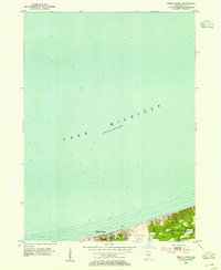
1953 Map of Ogden Dunes
USGS Topo · Published 1955About this map
Ogden Dunes occupies a thin strip of the southern Indiana shoreline in the early 1950s, bounded by the vast expanse of Lake Michigan and the industrial-minded hydrology of Burns Ditch. The map illustrates the town's early residential footprint alongside the natural topography of the lakeshore before the massive industrial expansion of the mid-20th century. Local landmarks like the Flowing Well and a Sand Pit suggest the area's transition from a natural landscape to one shaped by resource extraction and lakeside settlement. The inland portion of the quadrangle, including parts of Portage and Westchester townships, shows the interface between the lake’s bathymetry and the rising elevation of the dunes, providing a detailed record of the shoreline's physical state just before significant modern development altered the region.
Find a feature on this map
10 named features on this map. Tap any name to fly to it.
Don’t see what you’re looking for? This feature index may not catch every label — zoom into the map to look around manually.
Map Details
Editions of this 1953 Ogden Dunes Map
2 editions found
Other maps of this area

1900 · Toleston
USGS Topo · 1:62,500

1934 · Porter
USGS Topo · 1:48,000

1940 · Porter
USGS Topo · 1:62,500

1953 · Gary
USGS Topo · 1:24,000

1953 · Garyton
USGS Topo · 1:24,000

1953 · Chesterton
USGS Topo · 1:24,000

1953 · Dune Acres
USGS Topo · 1:24,000

1953 · Chicago
USGS Topo · 1:250,000

1957 · Chicago
USGS Topo · 1:250,000
1959 · Gary
USGS Topo · 1:24,000