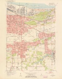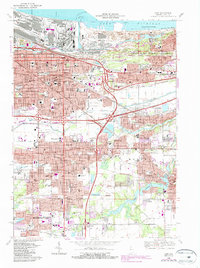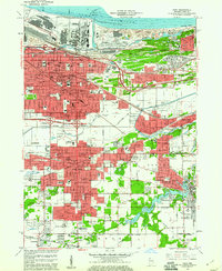
1959 Map of Gary
USGS Topo · Published 1961About this map
Industrial expansion and dense urban development define Gary at the end of the 1950s, a period when the city's identity was inseparable from the steel and rail lines that carved through its landscape. Massive infrastructure like the Gary Harbor and the Iron Ore Stockpile speak to the region's manufacturing might, while the grid of the city is densely packed with community institutions including St Marys Mercy Hospital and Froebel Sch. This survey captures the complexity of a landscape where nature and industry meet, from the shores of Lake Michigan at Marquette Park to the artificial channels of Burns Ditch. The presence of the Salvatorian Fathers Monastery and numerous parochial schools like Holy Angels Sch reflect the deep-rooted cultural and religious life of the workers' neighborhoods that fueled this manufacturing hub.
Find a feature on this map
109 named features on this map. Tap any name to fly to it.
Don’t see what you’re looking for? This feature index may not catch every label — zoom into the map to look around manually.
Map Details
Editions of this 1959 Gary Map
This is the sole edition of this map. No revisions or reprints were ever made.
Historical Maps of Gary Through Time
9 maps found