1960s Maps of Modoc, Indiana
Explore 3 historic maps of Modoc from the 1960s. These maps offer a rare glimpse into what life looked like during the 1960s — showing old roads, neighborhoods, homes, and landmarks that have changed or disappeared over time.
Whether you're researching your family's past, planning a metal detecting trip, or studying how Modoc's landscape evolved across the 1960s, these high-resolution maps are a powerful tool for exploring the history of this region.
- Focus on a specific era: All maps on this page are from the 1960s, giving you a focused view of this time period.
- See what’s changed: Compare century-old streets, trails, and buildings to today's modern landscape using overlays and satellite layers.
- Research with precision: Use these maps for genealogy, historical research, land use analysis, or educational projects.
- View, download, or print: Maps are fully viewable online in high resolution, and can be downloaded or printed for your own records.
Start exploring Modoc's history through authentic maps from the 1960s. This is your window into the past.
Modoc, IN maps
(3)- 1960 Map of Carlos, 1961 Print
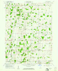 1960 Carlos1961 Print · USGSRandolph County's rural townships are captured here in the early sixties, showing the agricultural heartland of eastern Indiana. Researchers can trace historical property lines along the Indian Treaty Boundary and locate small communities like Huntsville, Unionport, and Carlos.3 unique versions available
 - 1960 Map of Modoc, 1961 Print
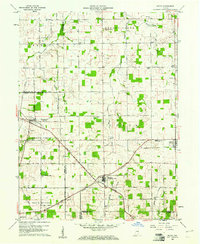 1960 Modoc1961 Print · USGSRandolph and Henry Counties appear here in the early sixties, centered on the vital rail junctions of the eastern Indiana plains. Genealogists and local historians can trace the locations of Bronson, Blountsville, and rural sites like Grace Chapel.
 - 1969 Map of Modoc, 1970 Print
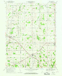 1969 Modoc1970 Print · USGSRandolph and Henry Counties are captured here in the late sixties, showing a landscape defined by intersecting railroads and rural crossroads. Genealogists and local historians can locate family landmarks like Poplar Run Cem, Union Ch, and the settlement of Blountsville.
End of results
Showing maps 1-3 of 3
Top cities near Modoc
- Muncie historical maps
- Richmond historical maps
- New Castle historical maps
- Winchester historical maps
- Centerville historical maps
- Cambridge City historical maps
See more
Frequently asked questions
- What are the different types of historical maps available for Modoc?
- What is the oldest map of Modoc?
- Where can I purchase historical maps of Modoc for my home or office?
- Where can I download high-res historical maps of Modoc?
- Are there historical topographic maps available for Modoc?
- Is there historical aerial imagery available for Modoc?
- Where are historical maps of Modoc sourced from?