1990s Maps of Mishawaka, Indiana
Explore 2 historic maps of Mishawaka from the 1990s. These maps offer a rare glimpse into what life looked like during the 1990s — showing old roads, neighborhoods, homes, and landmarks that have changed or disappeared over time.
Whether you're researching your family's past, planning a metal detecting trip, or studying how Mishawaka's landscape evolved across the 1990s, these high-resolution maps are a powerful tool for exploring the history of this region.
- Focus on a specific era: All maps on this page are from the 1990s, giving you a focused view of this time period.
- See what’s changed: Compare century-old streets, trails, and buildings to today's modern landscape using overlays and satellite layers.
- Research with precision: Use these maps for genealogy, historical research, land use analysis, or educational projects.
- View, download, or print: Maps are fully viewable online in high resolution, and can be downloaded or printed for your own records.
Start exploring Mishawaka's history through authentic maps from the 1990s. This is your window into the past.
Mishawaka, IN maps
(2)- 1992 Map of Wyatt, 1995 Print
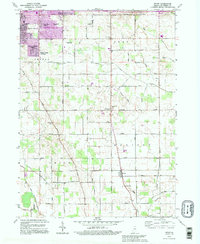 1992 Wyatt1995 Print · USGSSouth St. Joseph County transitioned from suburban expansion to traditional farmland in the early nineties. Genealogists and local historians can trace legacy sites like Union Ch Cem, Hay Sch, and the small community of Wyatt.
 - 1992 Map of South Bend East, 1995 Print
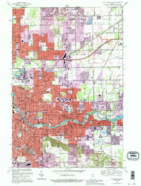 1992 South Bend East1995 Print · USGSSouth Bend and Mishawaka are shown during a period of significant late-century growth along the St Joseph River. Genealogists and historians can trace neighborhood development near the University of Notre Dame and locate local landmarks like Stuckey Cem and Clay High Sch.
End of results
Showing maps 1-2 of 2
Top cities near Mishawaka
- South Bend historical maps
- Elkhart historical maps
- Granger historical maps
- Niles historical maps
- Nappanee historical maps
- Notre Dame historical maps
See more
Frequently asked questions
- What are the different types of historical maps available for Mishawaka?
- What is the oldest map of Mishawaka?
- Where can I purchase historical maps of Mishawaka for my home or office?
- Where can I download high-res historical maps of Mishawaka?
- Are there historical topographic maps available for Mishawaka?
- Is there historical aerial imagery available for Mishawaka?
- Where are historical maps of Mishawaka sourced from?