1960s Maps of Clarks Hill, Indiana
Explore 2 historic maps of Clarks Hill from the 1960s. These maps offer a rare glimpse into what life looked like during the 1960s — showing old roads, neighborhoods, homes, and landmarks that have changed or disappeared over time.
Whether you're researching your family's past, planning a metal detecting trip, or studying how Clarks Hill's landscape evolved across the 1960s, these high-resolution maps are a powerful tool for exploring the history of this region.
- Focus on a specific era: All maps on this page are from the 1960s, giving you a focused view of this time period.
- See what’s changed: Compare century-old streets, trails, and buildings to today's modern landscape using overlays and satellite layers.
- Research with precision: Use these maps for genealogy, historical research, land use analysis, or educational projects.
- View, download, or print: Maps are fully viewable online in high resolution, and can be downloaded or printed for your own records.
Start exploring Clarks Hill's history through authentic maps from the 1960s. This is your window into the past.
Clarks Hill, IN maps
(2)- 1961 Map of Mulberry, 1962 Print
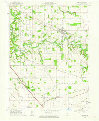 1961 Mulberry1962 Print · USGSClinton and Tippecanoe counties are shown in the early sixties as a productive agricultural region anchored by the railroad. Genealogists and historians can trace numerous rural family burial grounds like Baker Cem and Newcomer Cem, or locate the Clover Leaf Ch near the village of Fickle.3 unique versions available
 - 1962 Map of Colfax, 1963 Print
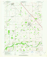 1962 Colfax1963 Print · USGSColfax and the surrounding rural townships are shown here in the early sixties at a peak of mid-century rail activity. Genealogists can trace family connections through numerous local burial sites including Union Cem, Shilo Cem, and Plainview Cem near the banks of Sugar Creek.2 unique versions available
End of results
Showing maps 1-2 of 2
Top cities near Clarks Hill
- Lafayette historical maps
- West Lafayette historical maps
- Frankfort historical maps
- Lebanon historical maps
- Crawfordsville historical maps
- Shadeland historical maps
See more
Frequently asked questions
- What are the different types of historical maps available for Clarks Hill?
- What is the oldest map of Clarks Hill?
- Where can I purchase historical maps of Clarks Hill for my home or office?
- Where can I download high-res historical maps of Clarks Hill?
- Are there historical topographic maps available for Clarks Hill?
- Is there historical aerial imagery available for Clarks Hill?
- Where are historical maps of Clarks Hill sourced from?