1960s Maps of Vanderburgh County, Indiana
Explore 8 historic maps of Vanderburgh County from the 1960s. These maps offer a rare glimpse into what life looked like during the 1960s — showing old roads, neighborhoods, homes, and landmarks that have changed or disappeared over time.
Whether you're researching your family's past, planning a metal detecting trip, or studying how Vanderburgh County's landscape evolved across the 1960s, these high-resolution maps are a powerful tool for exploring the history of this region.
- Focus on a specific era: All maps on this page are from the 1960s, giving you a focused view of this time period.
- See what’s changed: Compare century-old streets, trails, and buildings to today's modern landscape using overlays and satellite layers.
- Research with precision: Use these maps for genealogy, historical research, land use analysis, or educational projects.
- View, download, or print: Maps are fully viewable online in high resolution, and can be downloaded or printed for your own records.
Start exploring Vanderburgh County's history through authentic maps from the 1960s. This is your window into the past.
Vanderburgh County, IN maps
(8)- 1961 Map of Evansville
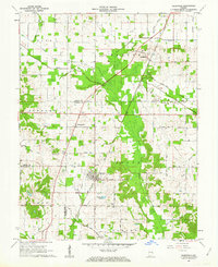
 1961 Evansville1961 Print · USGSThe Ohio River valley and its surrounding coalfields are captured here during the late fifties and early sixties. Trace the industrial rail networks of the Illinois Central RR and explore regional landmarks like Mammoth Cave National Park and Angel Mounds State Memorial.2 unique versions available
 - 1961 Map of Cynthiana, 1962 Print
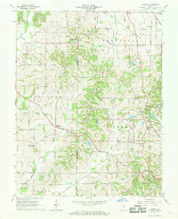
 1961 Cynthiana1962 Print · USGSCynthiana and the surrounding Tri-State area are captured here in the early sixties at a peak of rail and rural development. Genealogists and researchers can trace local family landmarks such as Blythe Chapel, Antioch Ch, and the Knowles Cem burial ground.3 unique versions available
 - 1961 Map of Elberfeld, 1963 Print
 1961 Elberfeld1963 Print · USGSThe rural landscape around Elberfeld and Buckskin in the early sixties was a unique blend of active energy production and historical transit routes. Local historians can trace the path of the Erie and Wabash Canal and locate family sites like Nobles Cem or Zion Cem.4 unique versions available
 - 1961 Map of Daylight, 1963 Print
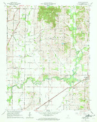 1961 Daylight1963 Print · USGSWarrick and Vanderburgh counties are shown in the early sixties as rural life centered on the rail corridors of the New York Central. Researchers can trace the legacy of the Wabash and Erie Canal or locate local landmarks like Daylight Sch and Blue Grass Cem.4 unique versions available
 - 1961 Map of Kasson, 1963 Print
 1961 Kasson1963 Print · USGSThe rural border of Vanderburgh and Posey counties is captured here in the early sixties, showing a landscape of oil production and scattered farming hamlets. Genealogists can locate family landmarks like Parkers Settlement, Engleheim Cem, and the Memorial Cem Ch.2 unique versions available
 - 1961 Map of Haubstadt, 1963 Print
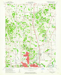
 1961 Haubstadt1963 Print · USGSSouthern Indiana at the start of the 1960s was a landscape defined by small-town rail commerce and emerging oil production. Researchers can trace family roots through numerous churches like St Stephen Ch and local landmarks such as Fort Branch or the Coal Mine.3 unique versions available
 - 1961 Map of Evansville North, 1963 Print
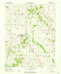
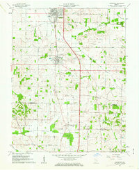
 1961 Evansville North1963 Print · USGSNorth of the city in the early sixties, this area shows the transition from rural Vanderburgh County to suburban neighborhoods and industrial sites. Genealogists can locate family sites near St Joseph Cemetery, Darmstadt, and schools like Rex Mundi High Sch.
 - 1964 Map of Newburgh, 1966 Print
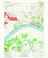 1964 Newburgh1966 Print · USGSThe Indiana-Kentucky borderlands at the bend of the Ohio River come into focus in the mid-1960s as Evansville's suburbs meet older river towns. Researchers can locate the historic Angel Mounds State Memorial, trace the Louisville and Nashville rail line, and find family markers at Rose Hill Cem.3 unique versions available
End of results
Showing maps 1-8 of 8
Top cities of Vanderburgh County
Frequently asked questions
- What are the different types of historical maps available for Vanderburgh County?
- What is the oldest map of Vanderburgh County?
- Where can I purchase historical maps of Vanderburgh County for my home or office?
- Where can I download high-res historical maps of Vanderburgh County?
- Are there historical topographic maps available for Vanderburgh County?
- Is there historical aerial imagery available for Vanderburgh County?
- Where are historical maps of Vanderburgh County sourced from?