1990s Maps of Vanderburgh County, Indiana
Explore 2 historic maps of Vanderburgh County from the 1990s. These maps offer a rare glimpse into what life looked like during the 1990s — showing old roads, neighborhoods, homes, and landmarks that have changed or disappeared over time.
Whether you're researching your family's past, planning a metal detecting trip, or studying how Vanderburgh County's landscape evolved across the 1990s, these high-resolution maps are a powerful tool for exploring the history of this region.
- Focus on a specific era: All maps on this page are from the 1990s, giving you a focused view of this time period.
- See what’s changed: Compare century-old streets, trails, and buildings to today's modern landscape using overlays and satellite layers.
- Research with precision: Use these maps for genealogy, historical research, land use analysis, or educational projects.
- View, download, or print: Maps are fully viewable online in high resolution, and can be downloaded or printed for your own records.
Start exploring Vanderburgh County's history through authentic maps from the 1990s. This is your window into the past.
Vanderburgh County, IN maps
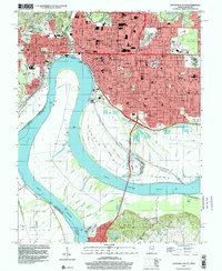
(2)- 1991 Map of Evansville
 1991 Evansville1991 Print · USGSThe tri-state region of Indiana and Kentucky was a hub of river commerce and rail transport in the early nineties. Researchers can trace the industrial corridor between Evansville and Owensboro, locating landmarks like Angel Mounds State Memorial and the Seaboard System railroad.
 - 1999 Map of Evansville South, 2001 Print
 1999 Evansville South2001 Print · USGSEvansville and the surrounding river bottomlands are captured at the end of the millennium as a major regional crossroads between Indiana and Kentucky. Local historians can trace the urban footprint of Evansville University and Evansville State Hospital, or explore the wooded terrain of John James Audubon State Park.
End of results
Showing maps 1-2 of 2
Top cities of Vanderburgh County
Frequently asked questions
- What are the different types of historical maps available for Vanderburgh County?
- What is the oldest map of Vanderburgh County?
- Where can I purchase historical maps of Vanderburgh County for my home or office?
- Where can I download high-res historical maps of Vanderburgh County?
- Are there historical topographic maps available for Vanderburgh County?
- Is there historical aerial imagery available for Vanderburgh County?
- Where are historical maps of Vanderburgh County sourced from?