1991 Map of Evansville
USGS Topo · Published 1991About this map
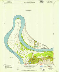
The Ohio River and its major tributaries, including the Green River and Wabash River, dominate this 1991 regional landscape where Indiana and Kentucky meet. The map documents the sprawling industrial and transportation corridor between Evansville, Henderson, and Owensboro, connected by toll roads like the Audubon Parkway and major rail lines including the Seaboard System and Illinois Central Gulf. Amidst the heavy infrastructure, significant conservation and cultural sites are visible, from the historic Angel Mounds State Memorial to the riparian wetlands of the Sloughs State Wildlife Mgmt Area and John James Audubon State Park. Geologists and historians can trace the intricate river morphology around Diamond Island and the varied terrain of Graham Hill, reflecting the region's long-standing reliance on river-and-rail commerce.
Find a feature on this map
59 named features on this map. Tap any name to fly to it.
Don’t see what you’re looking for? This feature index may not catch every label — zoom into the map to look around manually.
Map Details
Editions of this 1991 Evansville Map
This is the sole edition of this map. No revisions or reprints were ever made.
Historical Maps of Evansville Through Time
6 maps found