1940s Maps of Vermillion County, Indiana
Explore 3 historic maps of Vermillion County from the 1940s. These maps offer a rare glimpse into what life looked like during the 1940s — showing old roads, neighborhoods, homes, and landmarks that have changed or disappeared over time.
Whether you're researching your family's past, planning a metal detecting trip, or studying how Vermillion County's landscape evolved across the 1940s, these high-resolution maps are a powerful tool for exploring the history of this region.
- Focus on a specific era: All maps on this page are from the 1940s, giving you a focused view of this time period.
- See what’s changed: Compare century-old streets, trails, and buildings to today's modern landscape using overlays and satellite layers.
- Research with precision: Use these maps for genealogy, historical research, land use analysis, or educational projects.
- View, download, or print: Maps are fully viewable online in high resolution, and can be downloaded or printed for your own records.
Start exploring Vermillion County's history through authentic maps from the 1940s. This is your window into the past.
Vermillion County, IN maps
(3)- 1947 Map of Ridge Farm
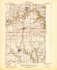 1947 Ridge Farm1947 Print · USGSEastern Illinois and the Indiana border appear here just after the war, showcasing a landscape of rail-connected towns and country school districts. Researchers can trace family history through dozens of landmarks like Scotland Sta, Vermilion Grove, and Harrison Consolidated Sch.3 unique versions available
 - 1947 Map of Paris, 1967 Print
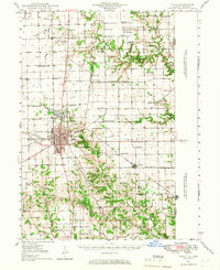 1947 Paris1967 Print · USGSPost-war Edgar County and the Indiana borderlands are captured here at a time when rural schoolhouses and small family cemeteries still marked nearly every section. Genealogists can locate Edgar Cem, the Old Indian Boundary Line, and dozens of local schools like Plum Grove Sch.
 - 1949 Map of Paris
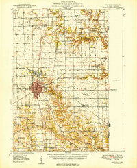 1949 Paris1949 Print · USGSEastern Illinois and the Indiana borderlands are captured here in the late 1940s, centered on the rail hub of Paris. Researchers can trace dozens of rural schoolhouses and family cemeteries, including St Aloysius Ch, Edgar Cem, and the path of the Old Indian Boundary Line.2 unique versions available
End of results
Showing maps 1-3 of 3
Top cities of Vermillion County
- Clinton historical maps
- Eugene historical maps
- Highland historical maps
- Fairview Park historical maps
- Cayuga historical maps
- Dana historical maps
See more
Frequently asked questions
- What are the different types of historical maps available for Vermillion County?
- What is the oldest map of Vermillion County?
- Where can I purchase historical maps of Vermillion County for my home or office?
- Where can I download high-res historical maps of Vermillion County?
- Are there historical topographic maps available for Vermillion County?
- Is there historical aerial imagery available for Vermillion County?
- Where are historical maps of Vermillion County sourced from?