1990s Maps of Vigo County, Indiana
Explore 3 historic maps of Vigo County from the 1990s. These maps offer a rare glimpse into what life looked like during the 1990s — showing old roads, neighborhoods, homes, and landmarks that have changed or disappeared over time.
Whether you're researching your family's past, planning a metal detecting trip, or studying how Vigo County's landscape evolved across the 1990s, these high-resolution maps are a powerful tool for exploring the history of this region.
- Focus on a specific era: All maps on this page are from the 1990s, giving you a focused view of this time period.
- See what’s changed: Compare century-old streets, trails, and buildings to today's modern landscape using overlays and satellite layers.
- Research with precision: Use these maps for genealogy, historical research, land use analysis, or educational projects.
- View, download, or print: Maps are fully viewable online in high resolution, and can be downloaded or printed for your own records.
Start exploring Vigo County's history through authentic maps from the 1990s. This is your window into the past.
Vigo County, IN maps
(3)- 1998 Map of Sandford, 2002 Print
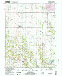 1998 Sandford2002 Print · USGSThe Illinois-Indiana borderlands come into focus in the late nineties, documenting the rural crossroads of Vermilion and Sandford. Researchers can trace ancestral roots at Shirkieville Cem or locate industrial sites like the Gas Storage Wells near Elbridge.
 - 1998 Map of Hutton, 2002 Print
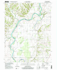 1998 Hutton2002 Print · USGSThe river border between Indiana and Illinois comes alive on this late-twentieth-century survey of the Wabash floodplain. Local historians can trace family roots at New Harmony Cem or Darwin Cem and locate old landmarks like Cooper Chapel and the Darwin Ferry.
 - 1998 Map of Dennison, 2002 Print
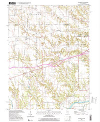 1998 Dennison2002 Print · USGSThe Illinois-Indiana borderlands appear here in the late twentieth century, showing a landscape of dispersed farmsteads and rural townships. Genealogists can locate family landmarks such as Farris Cem, Armstrong Sch, and the community at Dennison.
End of results
Showing maps 1-3 of 3
Top cities of Vigo County
- Terre Haute historical maps
- West Terre Haute historical maps
- Prairieton historical maps
- Prairie Creek historical maps
- Seelyville historical maps
- Riley historical maps
Frequently asked questions
- What are the different types of historical maps available for Vigo County?
- What is the oldest map of Vigo County?
- Where can I purchase historical maps of Vigo County for my home or office?
- Where can I download high-res historical maps of Vigo County?
- Are there historical topographic maps available for Vigo County?
- Is there historical aerial imagery available for Vigo County?
- Where are historical maps of Vigo County sourced from?