1960s Maps of Wabash, Indiana
Explore 2 historic maps of Wabash from the 1960s. These maps offer a rare glimpse into what life looked like during the 1960s — showing old roads, neighborhoods, homes, and landmarks that have changed or disappeared over time.
Whether you're researching your family's past, planning a metal detecting trip, or studying how Wabash's landscape evolved across the 1960s, these high-resolution maps are a powerful tool for exploring the history of this region.
- Focus on a specific era: All maps on this page are from the 1960s, giving you a focused view of this time period.
- See what’s changed: Compare century-old streets, trails, and buildings to today's modern landscape using overlays and satellite layers.
- Research with precision: Use these maps for genealogy, historical research, land use analysis, or educational projects.
- View, download, or print: Maps are fully viewable online in high resolution, and can be downloaded or printed for your own records.
Start exploring Wabash's history through authentic maps from the 1960s. This is your window into the past.
Wabash, IN maps
(2)- 1963 Map of Richvalley, 1964 Print
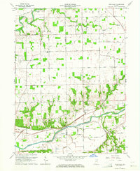 1963 Richvalley1964 Print · USGSRichvalley and the Wabash River corridor are captured here in the early sixties, showing the intersection of heavy rail and river valley life. Researchers can locate the Francis Godfroy Cem, trace the Wabash Railroad, and find early family sites along Carr Road.3 unique versions available
 - 1963 Map of Wabash, 1964 Print
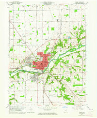 1963 Wabash1964 Print · USGSWabash and its surrounding townships are shown here during a period of post-war growth along the Wabash River. Researchers can trace old family sites across Speicherville, locate rural landmarks like Bachelor Creek Ch, or find historic burials at Falls Cem and Hebrew Cem.3 unique versions available
End of results
Showing maps 1-2 of 2
Top cities near Wabash
- Marion historical maps
- Peru historical maps
- North Manchester historical maps
- La Fontaine historical maps
- Sweetser historical maps
- Erie historical maps
See more
Top neighborhoods of Wabash
Frequently asked questions
- What are the different types of historical maps available for Wabash?
- What is the oldest map of Wabash?
- Where can I purchase historical maps of Wabash for my home or office?
- Where can I download high-res historical maps of Wabash?
- Are there historical topographic maps available for Wabash?
- Is there historical aerial imagery available for Wabash?
- Where are historical maps of Wabash sourced from?