1960s Maps of Richmond, Indiana
Explore 5 historic maps of Richmond from the 1960s. These maps offer a rare glimpse into what life looked like during the 1960s — showing old roads, neighborhoods, homes, and landmarks that have changed or disappeared over time.
Whether you're researching your family's past, planning a metal detecting trip, or studying how Richmond's landscape evolved across the 1960s, these high-resolution maps are a powerful tool for exploring the history of this region.
- Focus on a specific era: All maps on this page are from the 1960s, giving you a focused view of this time period.
- See what’s changed: Compare century-old streets, trails, and buildings to today's modern landscape using overlays and satellite layers.
- Research with precision: Use these maps for genealogy, historical research, land use analysis, or educational projects.
- View, download, or print: Maps are fully viewable online in high resolution, and can be downloaded or printed for your own records.
Start exploring Richmond's history through authentic maps from the 1960s. This is your window into the past.
Richmond, IN maps
(5)- 1960 Map of Fairhaven, 1961 Print
 1960 Fairhaven1961 Print · USGSThe Indiana-Ohio state line was a landscape of quiet agricultural hamlets and steam-era rail lines in the early sixties. Genealogists can trace the rural communities of Fairhaven and Goodwins Corner, along with the Sugar Grove Ch and several local cemeteries.2 unique versions available
 - 1960 Map of Fountain City, 1961 Print
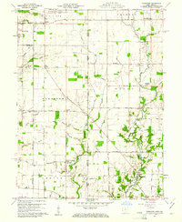
 1960 Fountain City1961 Print · USGSWayne County farming communities thrive in the early 1960s amidst a landscape carved by the Whitewater River and Nolands Fork. Genealogists can trace family roots at Old Concord Cem or Hopewell Ch, while discovering landmarks like the Covered Bridge on Quill Creek.
 - 1960 Map of Richmond, 1961 Print
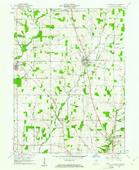
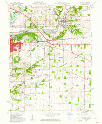
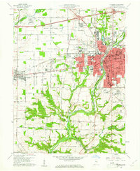 1960 Richmond1961 Print · USGSRichmond and Centerville are captured at a point of mid-century growth when rail lines still defined the local economy. Researchers can trace the grounds of Earlham College, find family plots at Earlham Cemetery, and locate vanished neighborhood landmarks like Sevastopol Sch.2 unique versions available
 - 1960 Map of Whitewater, 1961 Print
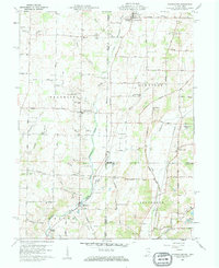 1960 Whitewater1961 Print · USGSThe Indiana-Ohio borderlands at the start of the sixties reveal a landscape of thriving crossroads and river-valley farms. Genealogists can trace family footprints through the Middleboro settlement, Friendship Ch, and several rural burial grounds like Bethel Cem.3 unique versions available
 - 1960 Map of New Paris, 1961 Print
 1960 New Paris1961 Print · USGSThe Indiana-Ohio border comes alive in the early sixties as the city of Richmond expands toward New Paris. Genealogists and historians can trace family locations through Smyrna Ch, Spring Lawn Cemetery, and the many farms along the historic National Road.4 unique versions available
End of results
Showing maps 1-5 of 5
Top cities near Richmond
- Connersville historical maps
- Eaton historical maps
- Centerville historical maps
- Camden historical maps
- Liberty historical maps
- New Paris historical maps
See more
Top neighborhoods of Richmond
Frequently asked questions
- What are the different types of historical maps available for Richmond?
- What is the oldest map of Richmond?
- Where can I purchase historical maps of Richmond for my home or office?
- Where can I download high-res historical maps of Richmond?
- Are there historical topographic maps available for Richmond?
- Is there historical aerial imagery available for Richmond?
- Where are historical maps of Richmond sourced from?