1990s Maps of Wells County, Indiana
Explore 2 historic maps of Wells County from the 1990s. These maps offer a rare glimpse into what life looked like during the 1990s — showing old roads, neighborhoods, homes, and landmarks that have changed or disappeared over time.
Whether you're researching your family's past, planning a metal detecting trip, or studying how Wells County's landscape evolved across the 1990s, these high-resolution maps are a powerful tool for exploring the history of this region.
- Focus on a specific era: All maps on this page are from the 1990s, giving you a focused view of this time period.
- See what’s changed: Compare century-old streets, trails, and buildings to today's modern landscape using overlays and satellite layers.
- Research with precision: Use these maps for genealogy, historical research, land use analysis, or educational projects.
- View, download, or print: Maps are fully viewable online in high resolution, and can be downloaded or printed for your own records.
Start exploring Wells County's history through authentic maps from the 1990s. This is your window into the past.
Wells County, IN maps
(2)- 1992 Map of Domestic, 1995 Print
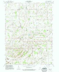 1992 Domestic1995 Print · USGSJay and Wells County crossroads are captured here in the early nineties, showing a landscape shaped by rural industry and drainage engineering. Genealogists can locate family sites near Domestic, Perryville, and the West Grove Cem or trace the early Oil Wells near Twin Hills.
 - 1994 Map of Poe, 1995 Print
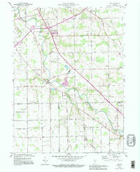 1994 Poe1995 Print · USGSNortheastern Indiana farmland at the close of the twentieth century is captured here as the St Marys River meanders through Allen County. Genealogists can locate family landmarks like Bethel Cem, Scheiman Bridge, and the community of Hoagland in its mid-nineties state.
End of results
Showing maps 1-2 of 2
Top cities of Wells County
- Bluffton historical maps
- Ossian historical maps
- Nottingham historical maps
- Uniondale historical maps
- Poneto historical maps
- Vera Cruz historical maps
Frequently asked questions
- What are the different types of historical maps available for Wells County?
- What is the oldest map of Wells County?
- Where can I purchase historical maps of Wells County for my home or office?
- Where can I download high-res historical maps of Wells County?
- Are there historical topographic maps available for Wells County?
- Is there historical aerial imagery available for Wells County?
- Where are historical maps of Wells County sourced from?