1960s Maps of Ossian, Indiana
Explore 2 historic maps of Ossian from the 1960s. These maps offer a rare glimpse into what life looked like during the 1960s — showing old roads, neighborhoods, homes, and landmarks that have changed or disappeared over time.
Whether you're researching your family's past, planning a metal detecting trip, or studying how Ossian's landscape evolved across the 1960s, these high-resolution maps are a powerful tool for exploring the history of this region.
- Focus on a specific era: All maps on this page are from the 1960s, giving you a focused view of this time period.
- See what’s changed: Compare century-old streets, trails, and buildings to today's modern landscape using overlays and satellite layers.
- Research with precision: Use these maps for genealogy, historical research, land use analysis, or educational projects.
- View, download, or print: Maps are fully viewable online in high resolution, and can be downloaded or printed for your own records.
Start exploring Ossian's history through authentic maps from the 1960s. This is your window into the past.
Ossian, IN maps
(2)- 1962 Map of Uniondale, 1963 Print
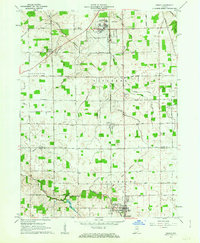
 1962 Uniondale1963 Print · USGSWells County at the start of the 1960s shows a landscape of river-bend settlements and expanding rural infrastructure. Genealogists and local historians can trace family sites near Murray Cem, Lancaster Central Sch, and the Erie-Lackawanna rail line.2 unique versions available
 - 1962 Map of Ossian, 1963 Print
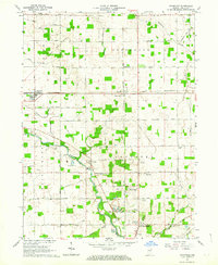
 1962 Ossian1963 Print · USGSAllen and Wells Counties are shown in the early sixties, a time of small-town growth and established aviation infrastructure. Genealogists can trace family footprints across Oak Lawn Cem, the Fairview Ch, and local schools like St Marks Sch.2 unique versions available
End of results
Showing maps 1-2 of 2
Top cities near Ossian
- Fort Wayne historical maps
- Aboite historical maps
- New Haven historical maps
- Bluffton historical maps
- Decatur historical maps
- Berne historical maps
See more
Top neighborhoods of Ossian
Frequently asked questions
- What are the different types of historical maps available for Ossian?
- What is the oldest map of Ossian?
- Where can I purchase historical maps of Ossian for my home or office?
- Where can I download high-res historical maps of Ossian?
- Are there historical topographic maps available for Ossian?
- Is there historical aerial imagery available for Ossian?
- Where are historical maps of Ossian sourced from?