1960s Maps of Monticello, Indiana
Explore 3 historic maps of Monticello from the 1960s. These maps offer a rare glimpse into what life looked like during the 1960s — showing old roads, neighborhoods, homes, and landmarks that have changed or disappeared over time.
Whether you're researching your family's past, planning a metal detecting trip, or studying how Monticello's landscape evolved across the 1960s, these high-resolution maps are a powerful tool for exploring the history of this region.
- Focus on a specific era: All maps on this page are from the 1960s, giving you a focused view of this time period.
- See what’s changed: Compare century-old streets, trails, and buildings to today's modern landscape using overlays and satellite layers.
- Research with precision: Use these maps for genealogy, historical research, land use analysis, or educational projects.
- View, download, or print: Maps are fully viewable online in high resolution, and can be downloaded or printed for your own records.
Start exploring Monticello's history through authentic maps from the 1960s. This is your window into the past.
Monticello, IN maps
(3)- 1962 Map of Monticello South, 1963 Print
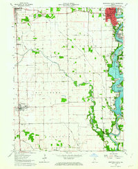 1962 Monticello South1963 Print · USGSWhite County enters a new era of lakeside living in the early sixties as development spreads along the shores of Lake Freeman. Researchers can trace the civic growth of Monticello or locate family roots at Bunnell Cem and the small whistle-stop of Smithson.2 unique versions available
 - 1962 Map of Monticello North, 1964 Print
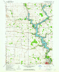 1962 Monticello North1964 Print · USGSWhite County was a hub of river activity and rail transport in the early sixties as leisure life expanded along the water. Genealogists can trace family roots through rural landmarks like Wilson Cem, Bedford Ch, and the vanished Twp Sch.2 unique versions available
 - 1962 Map of Yeoman, 1964 Print
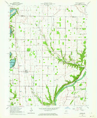 1962 Yeoman1964 Print · USGSCarroll and White counties come alive in the early sixties as recreational lakeside communities began to grow alongside traditional rail-towns. Genealogists and local historians can trace family roots at Schock Cem and River View Cem or follow the historic Monon Railroad through Yeoman.
End of results
Showing maps 1-3 of 3
Top cities near Monticello
- Delphi historical maps
- Monon historical maps
- Brookston historical maps
- Camden historical maps
- Reynolds historical maps
- Chalmers historical maps
See more
Frequently asked questions
- What are the different types of historical maps available for Monticello?
- What is the oldest map of Monticello?
- Where can I purchase historical maps of Monticello for my home or office?
- Where can I download high-res historical maps of Monticello?
- Are there historical topographic maps available for Monticello?
- Is there historical aerial imagery available for Monticello?
- Where are historical maps of Monticello sourced from?