1960s Maps of Larwill, Indiana
Explore 2 historic maps of Larwill from the 1960s. These maps offer a rare glimpse into what life looked like during the 1960s — showing old roads, neighborhoods, homes, and landmarks that have changed or disappeared over time.
Whether you're researching your family's past, planning a metal detecting trip, or studying how Larwill's landscape evolved across the 1960s, these high-resolution maps are a powerful tool for exploring the history of this region.
- Focus on a specific era: All maps on this page are from the 1960s, giving you a focused view of this time period.
- See what’s changed: Compare century-old streets, trails, and buildings to today's modern landscape using overlays and satellite layers.
- Research with precision: Use these maps for genealogy, historical research, land use analysis, or educational projects.
- View, download, or print: Maps are fully viewable online in high resolution, and can be downloaded or printed for your own records.
Start exploring Larwill's history through authentic maps from the 1960s. This is your window into the past.
Larwill, IN maps
(2)- 1962 Map of Pierceton, 1964 Print
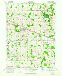 1962 Pierceton1964 Print · USGSNortheastern Indiana during the early 1960s shows a landscape of glacial lakes and small-town rail hubs. Trace the paths of the Pennsylvania Railroad and Lincoln Highway past Hillcrest Cem and Sellers Lake.2 unique versions available
 - 1965 Map of Lorane, 1966 Print
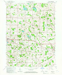 1965 Lorane1966 Print · USGSWhitley County is shown here in the mid-1960s as a landscape of agricultural drainage and lakeside communities. Genealogists can trace family names via Adams Cemetery or locate local centers like Larwill, Bethel Church, and the Township Sch.
End of results
Showing maps 1-2 of 2
Top cities near Larwill
- Warsaw historical maps
- Columbia City historical maps
- North Manchester historical maps
- Winona Lake historical maps
- Syracuse historical maps
- Albion historical maps
See more
Frequently asked questions
- What are the different types of historical maps available for Larwill?
- What is the oldest map of Larwill?
- Where can I purchase historical maps of Larwill for my home or office?
- Where can I download high-res historical maps of Larwill?
- Are there historical topographic maps available for Larwill?
- Is there historical aerial imagery available for Larwill?
- Where are historical maps of Larwill sourced from?