1940s Maps of Appanoose County, Iowa
Explore 4 historic maps of Appanoose County from the 1940s. These maps offer a rare glimpse into what life looked like during the 1940s — showing old roads, neighborhoods, homes, and landmarks that have changed or disappeared over time.
Whether you're researching your family's past, planning a metal detecting trip, or studying how Appanoose County's landscape evolved across the 1940s, these high-resolution maps are a powerful tool for exploring the history of this region.
- Focus on a specific era: All maps on this page are from the 1940s, giving you a focused view of this time period.
- See what’s changed: Compare century-old streets, trails, and buildings to today's modern landscape using overlays and satellite layers.
- Research with precision: Use these maps for genealogy, historical research, land use analysis, or educational projects.
- View, download, or print: Maps are fully viewable online in high resolution, and can be downloaded or printed for your own records.
Start exploring Appanoose County's history through authentic maps from the 1940s. This is your window into the past.
Appanoose County, IA maps
(4)- 1941 Map of Centerville
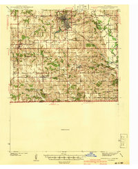 1941 Centerville1941 Print · USGSAppanoose County stands at a peak of rural development in the late thirties, where a dense network of railroads connects bustling border towns. Genealogists can trace family roots through numerous one-room schoolhouses like Cornbread College Sch and landmarks such as Livengod Cem.
 - 1942 Map of Mystic
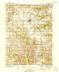
 1942 Mystic1942 Print · USGSSouthern Iowa coal and rail communities are mapped here just before the mid-century, showing a landscape tied to the Chariton River. Researchers can trace rural school districts like Hedge College Sch and vanished mining-era stops including Brazil and Rathbun.
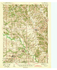
 - 1942 Map of Seymour, 1954 Print
 1942 Seymour1954 Print · USGSSouthern Iowa and the Missouri borderlands are captured here just as the rural schoolhouse era reached its peak. Genealogists can trace family roots through dozens of local landmarks like Genoa Cem, Locust Valley Mine, and the Kniffin Sch.
 - 1944 Map of Seymour
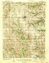 1944 Seymour1944 Print · USGSSouthern Iowa and northern Missouri are captured here in the early 1940s, showing a landscape defined by crossing rail lines and small-town junctions. Genealogists can locate numerous country schools and burial sites like Genoa Cem, Schultz Cem, and Happy Hollow Sch.2 unique versions available
End of results
Showing maps 1-4 of 4
Top cities of Appanoose County
- Centerville historical maps
- Moravia historical maps
- Moulton historical maps
- Mystic historical maps
- Cincinnati historical maps
- Exline historical maps
See more
Frequently asked questions
- What are the different types of historical maps available for Appanoose County?
- What is the oldest map of Appanoose County?
- Where can I purchase historical maps of Appanoose County for my home or office?
- Where can I download high-res historical maps of Appanoose County?
- Are there historical topographic maps available for Appanoose County?
- Is there historical aerial imagery available for Appanoose County?
- Where are historical maps of Appanoose County sourced from?