1980s Maps of Calhoun County, Iowa
Explore 13 historic maps of Calhoun County from the 1980s. These maps offer a rare glimpse into what life looked like during the 1980s — showing old roads, neighborhoods, homes, and landmarks that have changed or disappeared over time.
Whether you're researching your family's past, planning a metal detecting trip, or studying how Calhoun County's landscape evolved across the 1980s, these high-resolution maps are a powerful tool for exploring the history of this region.
- Focus on a specific era: All maps on this page are from the 1980s, giving you a focused view of this time period.
- See what’s changed: Compare century-old streets, trails, and buildings to today's modern landscape using overlays and satellite layers.
- Research with precision: Use these maps for genealogy, historical research, land use analysis, or educational projects.
- View, download, or print: Maps are fully viewable online in high resolution, and can be downloaded or printed for your own records.
Start exploring Calhoun County's history through authentic maps from the 1980s. This is your window into the past.
Calhoun County, IA maps
(13)- 1980 Map of Lytton
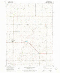 1980 Lytton1980 Print · USGSThe border of Sac and Calhoun counties comes into focus in the 1970s, centered on the railroad town of Lytton. Genealogists and local historians can locate St John Cem, Garfield Cem, and the path of the Chicago Milwaukee St Paul and Pacific line.
 - 1980 Map of Rockwell City
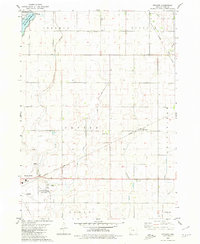
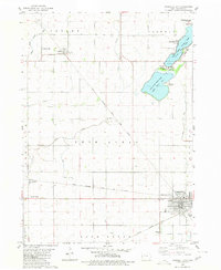 1980 Rockwell City1980 Print · USGSRockwell City and its surrounding lake country are captured here in the late 1970s, showcasing a landscape of prairie townships and rail-side grain stops. Researchers can trace family roots at Crown Hill Cem or locate community landmarks like the Drive-in Theater and Fairground.
 - 1980 Map of Sac City East
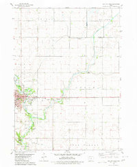 1980 Sac City East1980 Print · USGSSac City and the surrounding Iowa farmland are captured here in the early 1980s as the regional rail and river network remained vital. Genealogists and local historians can trace family locations near Oakland Cem, the Fairground, or along the Cedar Creek drainage.
 - 1980 Map of Carroll NE
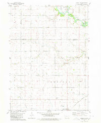 1980 Carroll NE1980 Print · USGSMid-century Iowa farm country unfolds across Carroll, Calhoun, and Sac counties as the eighties began. Researchers can trace the Chicago and North Western line to Lidderdale, find family plots at Cottonwood Cem, or locate the Flowing Well near the river.
 - 1980 Map of Yetter
 1980 Yetter1980 Print · USGSWestern Calhoun County is shown here in the late seventies, a time when rail and river still dictated the local geography. Researchers can trace the path of the Illinois Central Gulf through Yetter or locate the historic Cottonwood Cem.
 - 1980 Map of Wightman
 1980 Wightman1980 Print · USGSCalhoun and Greene counties appear at a crossroads in the early 1980s where the Iowa rail network meets the agricultural heartland. Researchers can trace the village of Wightman, follow the Chicago and North Western tracks, and locate St Patricks Ch.
 - 1980 Map of Lanesboro
 1980 Lanesboro1980 Print · USGSLanesboro and the surrounding Carroll County farmland are captured here in the late 1970s as the rail and river networks shaped local life. Genealogists and historians can locate Lanesboro Cem, trace the Chicago and North Western rail line, or find local landmarks like Vador Bridge.
 - 1980 Map of Richard
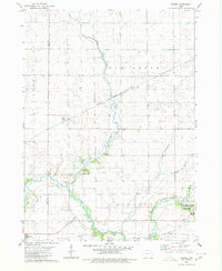
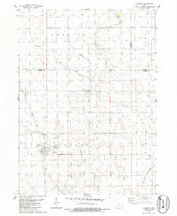
 1980 Richard1980 Print · USGSCalhoun County's agricultural landscape and the northern edge of Rockwell City are captured here in the early eighties. Local researchers can trace the routes of the Illinois Central Gulf railroad through Richard or locate Rosehill Cem and the County Home.
 - 1980 Map of Lohrville
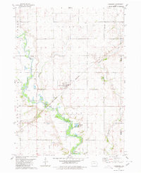
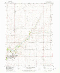
 1980 Lohrville1980 Print · USGSLohrville and the surrounding Calhoun County townships are shown here as an important agricultural rail hub during the late 1970s. Trace the intersection of two major lines, find the St Joseph Cem, and locate smaller rail outposts like Piper and Rands.
 - 1980 Map of Lake City
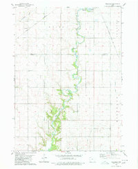
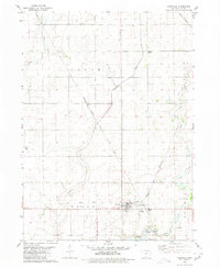
 1980 Lake City1980 Print · USGSCalhoun County's agricultural and civic heart is captured here in the late twentieth century, centered on the bustling hub of Lake City. Researchers can trace the local infrastructure from the Illinois Central Gulf railroad to the rural Lake Creek Cem and Lincoln Sch.
 - 1984 Map of Humboldt, 1985 Print
 1984 Humboldt1985 Print · USGSNorth Central Iowa in the mid-eighties shows a deeply integrated landscape of agricultural drainage and rail-connected settlements. Trace the rural layout of the era via the Chicago and North Western line, Rush Lake, and Lizard Lake County Park.2 unique versions available
 - 1985 Map of Carroll
 1985 Carroll1985 Print · USGSWest-Central Iowa in the mid-eighties shows a landscape of highly engineered farmland and river-valley conservation. Researchers can trace the drainage patterns of Purgatory Creek or locate local landmarks like Dolliver Memorial State Park and the rail-junction town of Gowrie.
 - 1985 Map of Churdan
 1985 Churdan1985 Print · USGSThis Greene County community is captured in the mid-1980s as its rail-dependent past began to shift into the modern era. Genealogists and local historians can trace the Old Railroad Grade near Adaza or locate family plots at Highland Cem.
End of results
Showing maps 1-13 of 13
Top cities of Calhoun County
- Rockwell City historical maps
- Lake City historical maps
- Manson historical maps
- Pomeroy historical maps
- Farnhamville historical maps
- Lohrville historical maps
See more
Frequently asked questions
- What are the different types of historical maps available for Calhoun County?
- What is the oldest map of Calhoun County?
- Where can I purchase historical maps of Calhoun County for my home or office?
- Where can I download high-res historical maps of Calhoun County?
- Are there historical topographic maps available for Calhoun County?
- Is there historical aerial imagery available for Calhoun County?
- Where are historical maps of Calhoun County sourced from?