1980s Maps of Dewey, Iowa
Explore 2 historic maps of Dewey from the 1980s. These maps offer a rare glimpse into what life looked like during the 1980s — showing old roads, neighborhoods, homes, and landmarks that have changed or disappeared over time.
Whether you're researching your family's past, planning a metal detecting trip, or studying how Dewey's landscape evolved across the 1980s, these high-resolution maps are a powerful tool for exploring the history of this region.
- Focus on a specific era: All maps on this page are from the 1980s, giving you a focused view of this time period.
- See what’s changed: Compare century-old streets, trails, and buildings to today's modern landscape using overlays and satellite layers.
- Research with precision: Use these maps for genealogy, historical research, land use analysis, or educational projects.
- View, download, or print: Maps are fully viewable online in high resolution, and can be downloaded or printed for your own records.
Start exploring Dewey's history through authentic maps from the 1980s. This is your window into the past.
Dewey, IA maps
(2)- 1980 Map of Dewey, 1981 Print
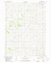 1980 Dewey1981 Print · USGSSouthwestern Iowa farm country is documented here in the late seventies, showing the rural townships of Victoria, Edna, and Union. Researchers can locate the Victoria Cem, the rail line of the Burlington Northern, and local churches like St Timothy Ch.
 - 1985 Map of Creston
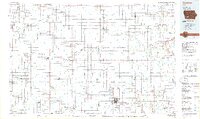 1985 Creston1985 Print · USGSSouthwest Iowa in the mid-eighties shows a landscape of established farm towns and growing regional hubs connected by vital rail lines. Genealogists and local historians can trace landmarks like Graceland Cem, the Southwestern Community College campus, and the Burlington Northern railroad route.
End of results
Showing maps 1-2 of 2
Top cities near Dewey
- Atlantic historical maps
- Corning historical maps
- Fontanelle historical maps
- Massena historical maps
- Cumberland historical maps
- Prescott historical maps
See more
Frequently asked questions
- What are the different types of historical maps available for Dewey?
- What is the oldest map of Dewey?
- Where can I purchase historical maps of Dewey for my home or office?
- Where can I download high-res historical maps of Dewey?
- Are there historical topographic maps available for Dewey?
- Is there historical aerial imagery available for Dewey?
- Where are historical maps of Dewey sourced from?