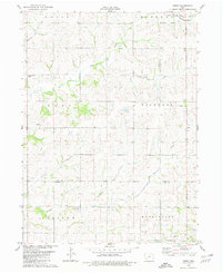
1980 Map of Dewey
USGS Topo · Published 1981About this map
The West Nodaway River and its numerous tributaries, including Elm Creek and Moore Creek, define the agricultural landscape of this corner of southwest Iowa. The terrain is a network of township divisions including Union, Edna, and Victoria, where small rural congregations established landmarks like St Peters Ch and St Timothy Ch. The settlement at Dewey sits near the eastern edge of the survey, while the Burlington Northern railroad cuts through the northeastern corner, following the river valley through the Massena Corporate Bdy. These rural crossroads, often marked by a single Radio Tower or a church such as the Mayflower Gospel Chapel, reveal the persistence of the 1970s farming community structure along the border of Cass and Adams Counties.
Find a feature on this map
20 named features on this map. Tap any name to fly to it.
Don’t see what you’re looking for? This feature index may not catch every label — zoom into the map to look around manually.
Map Details
Editions of this 1980 Dewey Map
This is the sole edition of this map. No revisions or reprints were ever made.
Other maps of this area

1954 · Omaha
USGS Topo · 1:250,000

1957 · Omaha
USGS Topo · 1:250,000

1958 · Omaha
USGS Topo · 1:250,000

1971 · Anita SW
USGS Topo · 1:24,000

1971 · Massena
USGS Topo · 1:24,000

1971 · Fontanelle SW
USGS Topo · 1:24,000

1980 · Corning North
USGS Topo · 1:24,000

1980 · Grant
USGS Topo · 1:24,000

1980 · Bridgewater
USGS Topo · 1:24,000
1980 · Carbon
USGS Topo · 1:24,000