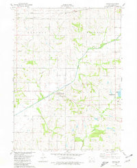
1980 Map of Carbon
USGS Topo · Published 1981About this map
The Middle Nodaway River carves a winding path through this corner of Adams County, where the small settlement of Carbon serves as a focal point near the confluence with Bull Creek. The landscape is defined by the intersection of four townships—Lincoln, Washington, Douglas, and Quincy—illustrating the traditional Midwestern survey grid. In the northeast, the development of the Lake Icaria County Recreation Area and Lake Icaria highlights a shift toward water management and public leisure space. Local heritage is grounded in sites like Lincoln Center and the village of Quincy, while the presence of the Quincy Cem and Oakland Cem provides valuable reference points for genealogical research. The map also documents modern infrastructure, including several pipelines that traverse the northern sections of the terrain.
Find a feature on this map
18 named features on this map. Tap any name to fly to it.
Don’t see what you’re looking for? This feature index may not catch every label — zoom into the map to look around manually.
Map Details
Editions of this 1980 Carbon Map
This is the sole edition of this map. No revisions or reprints were ever made.
Other maps of this area

1954 · Omaha
USGS Topo · 1:250,000

1955 · Nebraska City
USGS Topo · 1:250,000

1957 · Nebraska City
USGS Topo · 1:250,000

1957 · Omaha
USGS Topo · 1:250,000

1958 · Omaha
USGS Topo · 1:250,000

1958 · Nebraska City
USGS Topo · 1:250,000

1980 · Corning South
USGS Topo · 1:24,000

1980 · Corning North
USGS Topo · 1:24,000

1980 · Grant
USGS Topo · 1:24,000
1980 · Brooks
USGS Topo · 1:24,000